Home / World regions
World Regions Map
World regions are not internationally defined and depends on the sources. To give an appropriate view we will present the definition of the world regions used by the United Nation, the World Bank, the CIA World Factbook.
The United Nations Geoscheme

The United Nations Geoscheme is the system used by the United Nations for classifying the countries in regions and subregions. The United Nations Geoscheme was defined by the Standard Country or Area Codes for Statistical Use, commonly referred as the M49 standard, and it was defined by the Statistics Division of the United Nations Secretariat. The grouping of countries is not based on political or other affiliation, but only for statistical convenience.
Following the standard, each country is shown only in one region. The first level of division is based on continental regions. These first level of regions are further subdivided into sub-regions and intermediary regions. The main objective is to have subdivision to obtain greater homogeneity in sizes of population, demographic circumstances and accuracy of demographic statistics.
The divisions are the following:
- Africa
- Northern Africa
- Sub-Saharan Africa
- Eastern Africa
- Middle Africa
- Southern Africa
- Western Africa
- Americas
- Latin America and the Caribbean
- Caribbean
- Central America
- South America
- Northern America
- Latin America and the Caribbean
- Antarctica
- Asia
- Central Asia
- Eastern Asia
- South-eastern Asia
- southern Asia
- Western Asia
- Europe
- Eastern Europe
- Northern Europe
- Channel Islands
- Southern Europe
- Western Europe
- Oceania
- Australia and New Zealand
- Melanesia
- Micronesia
- Polynesia
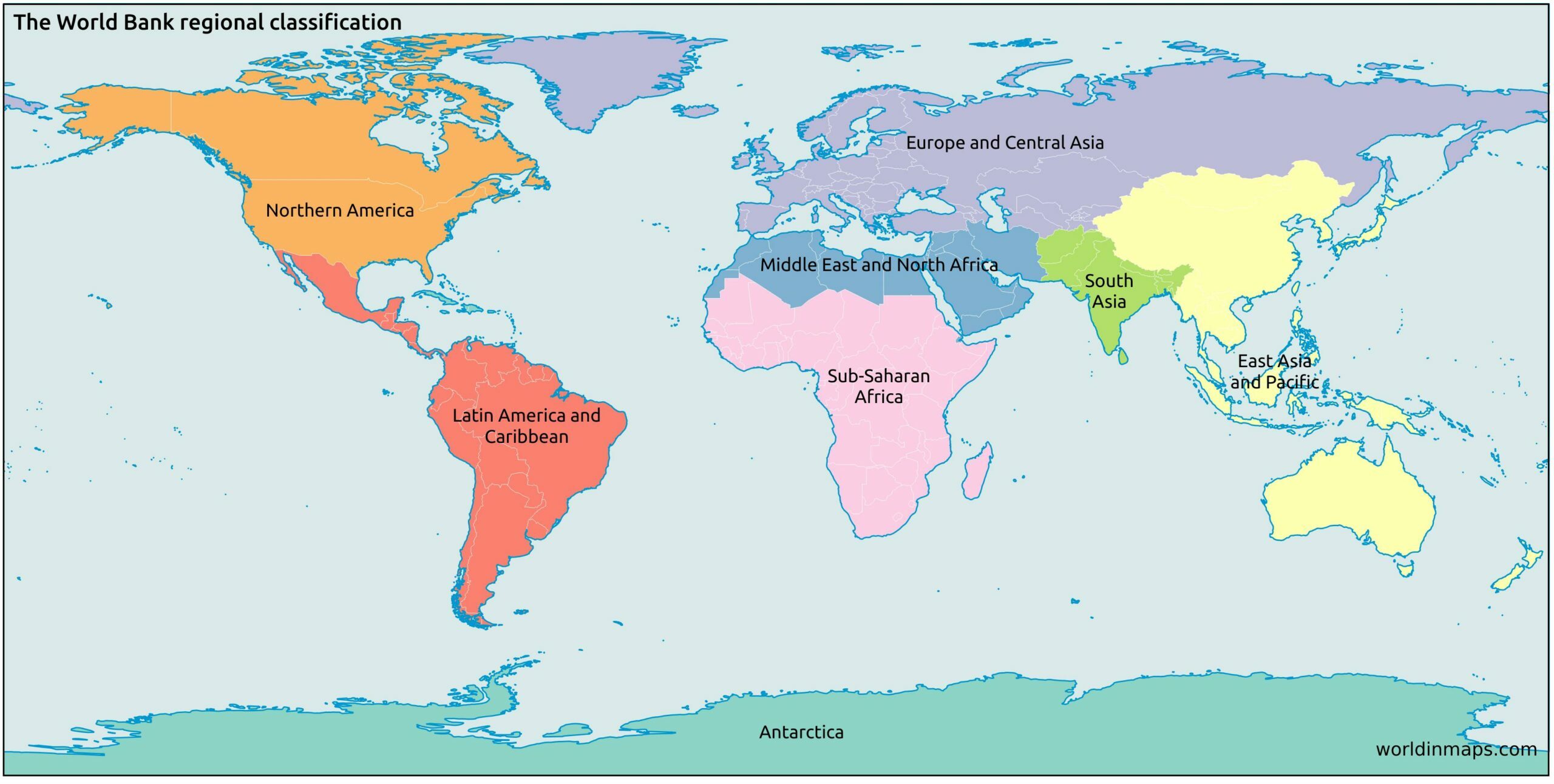
The World Bank regional classification
CIA World Factbook Regions

Recommended products
Atlases

Concise World Atlas: Everything You Need to Know About Our Planet Today
This easy to read atlas concentrate all the essential information an atlas is expected to have. It contains more than 640 maps with a lot of illustrations and pictures. The atlas cover the world’s physical, political, economic, and demographic geography.
Publisher: DK
Publication date: March 8, 2016
List price: $58.81

Collins World Atlas: Complete Edition
This atlas of the world presents a complete view of the world, bringing it to life through innovative maps, stunning images and detailed content. It covers a wide range of topical issues, including natural disasters, population, climate and the environment.
Publisher: Collins
Publication date: December 1, 2020
List price: $45.46

This atlas is updated annually and contains the most current geographic information. The Atlas is filled with maps of cities and regions. It contains also statistics, tables, graphs on numerous topics like climate change, oceans, seas, populations, energy, minerals, …
Publisher: Oxford University Press
Publication date: October 1, 2020
List price: $56.27
Globes

Advantus 12 Inch Desktop World Globe with Blue Oceans
This classical political globe of 12-inch shows the natural coloration of the earth to illustrate mountains, deserts, forest and grasslands. It also shows undersea physical features and raised relief. The globe is mounted on a silver-finish full meridian and base.
Size: 13 W x 12 L x 15 H in
List price: $53.99

Deco 79 Traditional Wood, Metal, and Plastic Decorative Globe, 14”H,9”W, Multicolored Finish
Traditional style globe with an iron axis and a mango wood base. Accurately depicted and labeled topographical map with muted gold, brown, green, gray, beige, and violet tones.
Size: 9 W x 9 L x 14 H in
List price: $ 41.17

Illuminated Globe – 3in1 World Globe, Constellation Globe Night Light, and Globe Lamp
Discover 88 constellations, stars, and navigational lines in the dark; this world globe features a stable and durable chromed steel globe stand and makes a great desk globe decor or smart globe light for any room at home or in the office
Size: 9 W x 9 L x 13.5 H in
List price: $49.95