States | Home / countries / United States / Alabama
Alabama
Table of contents
- Where is Alabama located?
- Map of Alabama
- Alabama counties map with the county seat cities
- Protected areas
- Birmingham Civil Rights National Monument
- Freedom Riders National Monument
- Horseshoe Bend National Military Parkbend
- Little River Canyon National Preserve
- Russell Cave National Monument
- Selma to Montgomery National Historical Trail
- Tuskegee Airmen National Historic Site
- Tuskegee Institute National Historic Site
- National Forests
- Must see in Alabama
Where is Alabama located?
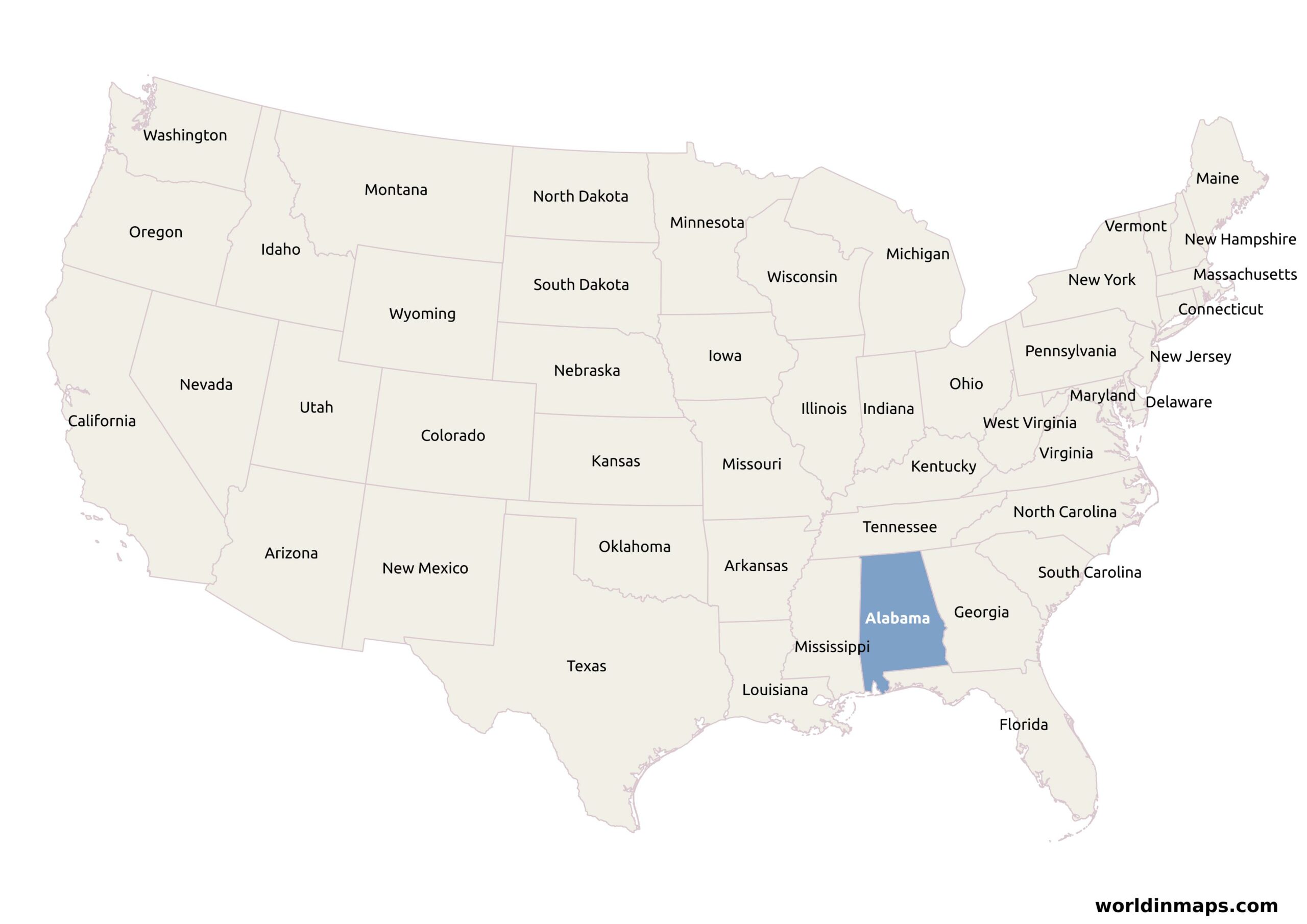
Alabama is a state located in the southeastern region of the United States. It is bordered on the north by Tennessee, on the west by Mississippi on the south by Florida and a little seashore on the Gulf of Mexico, and finally on the east by Georgia.
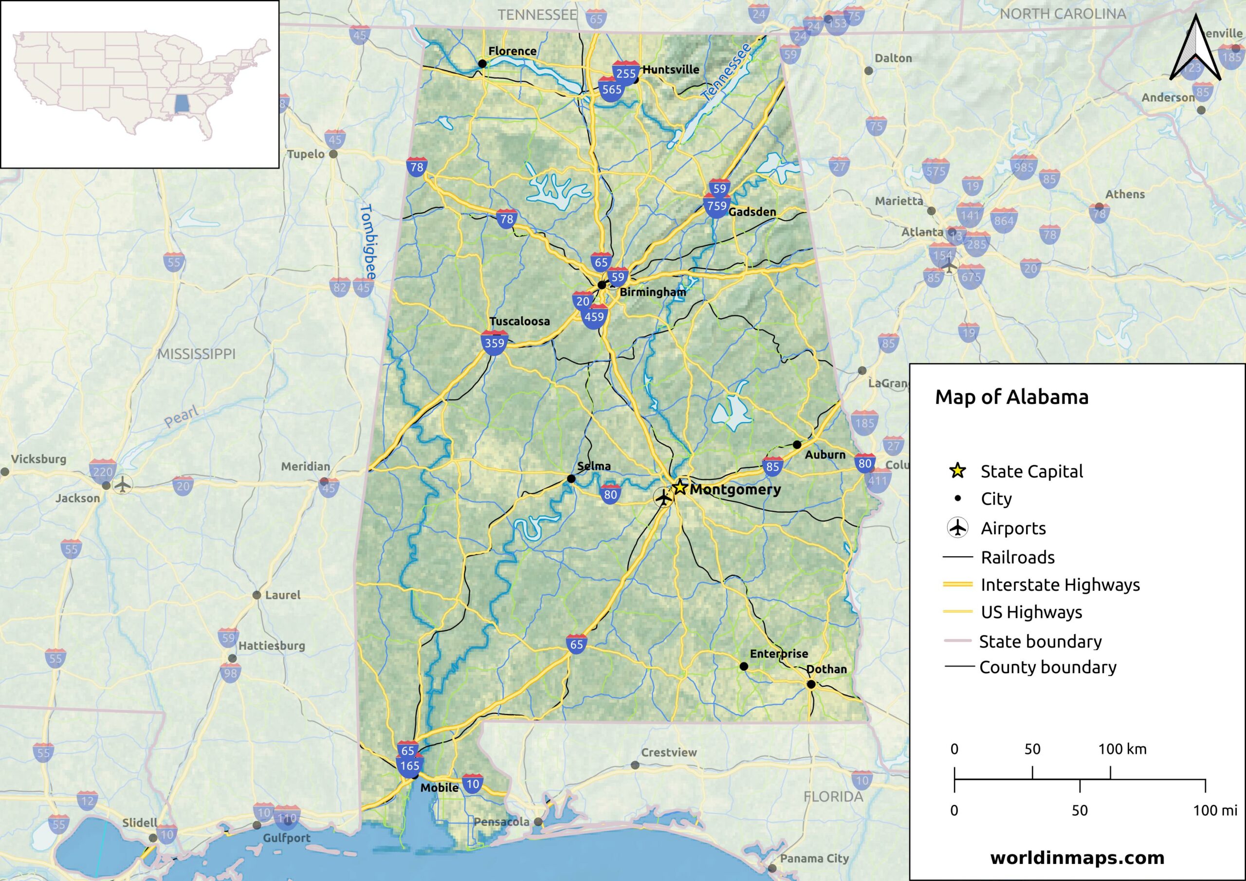
Map of Alabama
Alabama counties map with the county seat cities
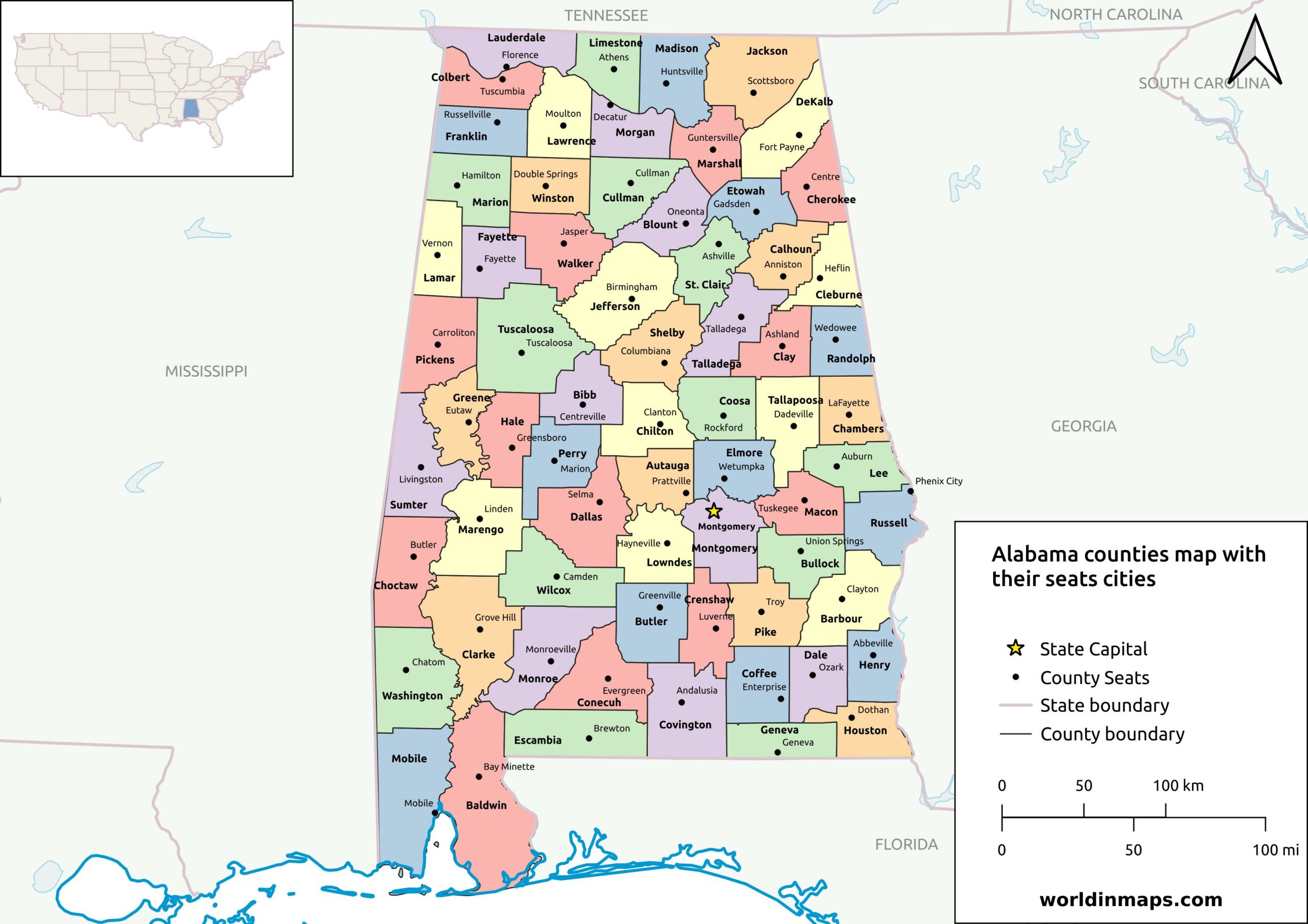
The U.S. state of Alabama has 67 counties. The table below lists all of them alphabetically with their County seat, their population and their area.
| County | County seat | Population | Area |
|---|---|---|---|
| Autauga County | Prattville | 58,805 | 594.44 sq mi (1,540 km²) |
| Baldwin County | Bay Minette | 231,767 | 1,589.78 sq mi (4,118 km²) |
| Barbour County | Clayton | 25,223 | 884.88 sq mi (2,292 km²) |
| Bibb County | Centreville | 22,293 | 622.58 sq mi (1,612 km²) |
| Blount County | Oneonta | 59,134 | 644.78 sq mi (1,670 km²) |
| Bullock County | Union Springs | 10,357 | 622.80 sq mi (1,613 km²) |
| Butler County | Greenville | 19,051 | 776.83 sq mi (2,012 km²) |
| Calhoun County | Anniston | 116,441 | 605.87 sq mi (1,569 km²) |
| Chambers County | LaFayette | 34,772 | 596.53 sq mi (1,545 km²) |
| Cherokee County | Centre | 24,971 | 553.70 sq mi (1,434 km²) |
| Chilton County | Clanton | 45,014 | 692,85 sq mi (1,794 km²) |
| Choctaw County | Butler | 12,665 | 913.50 sq mi (2,366 km²) |
| Clarke County | Grove Hill | 23,087 | 1,238.46 sq mi (3,208 km²) |
| Clay County | Ashland | 14,236 | 603.96 sq mi (1,564 km²) |
| Cleburne County | Heflin | 15,056 | 560.10 sq mi (1,451 km²) |
| Coffee County | Elba and Enterprise | 53,465 | 678.97 sq mi (1,759 km²) |
| Colbert County | Tuscumbia | 57,227 | 592.62 sq mi (1,535 km²) |
| Conecuh County | Evergreen | 11,597 | 850.16 sq mi (2,202 km²) |
| Coosa County | Rockford | 10,387 | 650.93 sq mi (1,686 km²) |
| Covington County | Andalusia | 37,570 | 1,030.46 sq mi (2,669 km²) |
| Crenshaw County | Luverne | 13,194 | 608.84 sq mi (1,577 km²) |
| Cullman County | Cullman | 87,866 | 734.84 sq mi (1,903 km²) |
| Dale County | Ozark | 49,326 | 561.15 sq mi (1,453 km²) |
| Dallas County | Selma | 38,462 | 978.69 sq mi (2,535 km²) |
| DeKalb County | Fort Payne | 71,608 | 777.09 sq mi (2,013 km²) |
| Elmore County | Wetumpka | 87,977 | 618.48 sq mi (1,602 km²) |
| Escambia County | Brewton | 36,757 | 945.08 sq mi (2,448 km²) |
| Etowah County | Gadsden | 103,436 | 534.99 sq mi (1,386 km²) |
| Fayette County | Fayette | 16,321 | 627.66 sq mi (1,626 km²) |
| Franklin County | Russelville | 32,113 | 633.82 sq mi (1,642 km²) |
| Geneva County | Geneva | 26,659 | 574.41 sq mi (1,488 km²) |
| Greene County | Eutaw | 7,730 | 647.11 sq mi (1,676 km²) |
| Hale County | Greensboro | 14,785 | 643.94 sq mi (1,668 km²) |
| Henry County | Abbeville | 17,146 | 561.75 sq mi (1,455 km²) |
| Houston County | Dothan | 107,202 | 579.82 sq mi (1,502 km²) |
| Jackson County | Scottsboro | 52,579 | 1,077.87 sq mi (2,792 km²) |
| Jefferson County | Birmingham | 674,721 | 1,111.28 sq mi (2,878 km²) |
| Lamar County | Vernon | 13,972 | 604.85 sq mi (1,567 km²) |
| Lauderdale County | Florence | 93,564 | 667.70 sq mi (1,729 km²) |
| Lawrence County | Moulton | 33,073 | 690.68 sq mi (1,789 km²) |
| Lee County | Opelika | 174,241 | 607.54 sq mi (1,574 km²) |
| Limestone County | Athens | 103,570 | 559.94 sq mi (1,450 km²) |
| Lowndes County | Hayneville | 10,311 | 715.91 sq mi (1,854 km²) |
| Macon County | Tuskegee | 19,532 | 608.89 sq mi (1,577 km²) |
| Madison County | Huntsville | 388,153 | 801.59 sq mi (2,076 km²) |
| Marengo County | Linden | 19,323 | 976.88 sq mi (2,530 km²) |
| Marion County | Hamilton | 29,341 | 742.29 sq mi (1,923 km²) |
| Marshall County | Guntersville | 97,612 | 565.84 sq mi (1,466 km²) |
| Mobile County | Mobile | 414,809 | 1,229.44 sq mi (3.184 km²) |
| Monroe County | Monroeville | 19,772 | 1,025.67 sq mi (2,656 km²) |
| Montgomery County | Montgomery | 228,954 | 784.25 sq mi (2,031 km²) |
| Morgan County | Decatur | 123,421 | 579.34 sq mi (1,500 km²) |
| Perry County | Marion | 8,511 | 719.66 sq mi (1,864 km²) |
| Pickens County | Carrollton | 19,123 | 881.41 sq mi (2,283 km²) |
| Pike County | Troy | 33,009 | 672.09 sq mi (1,741 km²) |
| Randolph County | Wedowee | 21,967 | 580.55 sq mi (1,504 km²) |
| Russell County | Phenix City | 59,183 | 641.14 sq mi (1,661 km²) |
| St. Clair County | Ashville and Pell City | 91,103 | 631.90 sq mi (1,637 km²) |
| Shelby County | Columbiana | 223,024 | 784.93 sq mi (2,033 km²) |
| Sumter County | Livingston | 12,345 | 903.89 sq mi (2,341 km²) |
| Talladega County | Talladega | 82,149 | 736.78 sq mi (1,908 km²) |
| Tallapoosa County | Dadeville | 41,311 | 716.52 sq mi (1,856 km²) |
| Tuscaloosa County | Tuscaloosa | 227,036 | 1,321.75 sq mi (3,423 km²) |
| Walker County | Jasper | 65,342 | 791.19 sq mi (2,049 km²) |
| Washington County | Chatom | 15,388 | 1,080.21 sq mi (2,798 km²) |
| Wilcox County | Camden | 10,600 | 888.50 sq mi (2,301 km²) |
| Winston County | Double Springs | 23,540 | 612.98 sq mi (1,588 km²) |
Protected areas

Birmingham Civil Rights National Monument
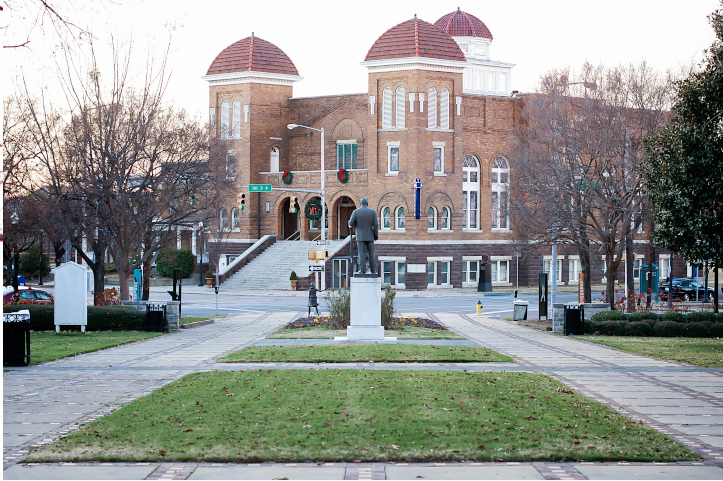
The Birmingham Civil Rights National Monument is located in Birmingham. It was established in 2017 to protect and commemorate the Civil Rights Movement. This movement was active between 1954 and 1968 to end legalized racial discrimination and segregation in the United States. Birmingham is indeed an important place of the anti racial movements. Birmingham was called nothing less than the most segregated city in the country by Martin Luther King Jr. It is from this city that he also write the Letter from Birmingham Jail.
Freedom Riders National Monument
The Freedom Riders National Monument is located in Anniston. It was also established in 2017 to preserve and commemorate the Freedom Riders during the Civil Rights Movement. The Freedom Riders were civil rights activists who rode interstate buses with mixed racial groups, which was against local laws. The National Monument is made of the former Greyhound bus depot in the downtown of Anniston where a bus of the Freedom Riders was attacked on May 14, 1961 and the second place is the site where the bus was finally burned, outside the town.
Horseshoe Bend National Military Park
The Horseshoe Bend National Military Park is located in the Tallapoosa County in Alabama on the place of the last battle of the Creek War on March 27, 1814. This battle (called the Battle of Horseshoe Bend) was opposing Tennessee militia, U.S. Infantry, Cherokee and Lower Creek who won from the Upper Creek Red Stick Nation.
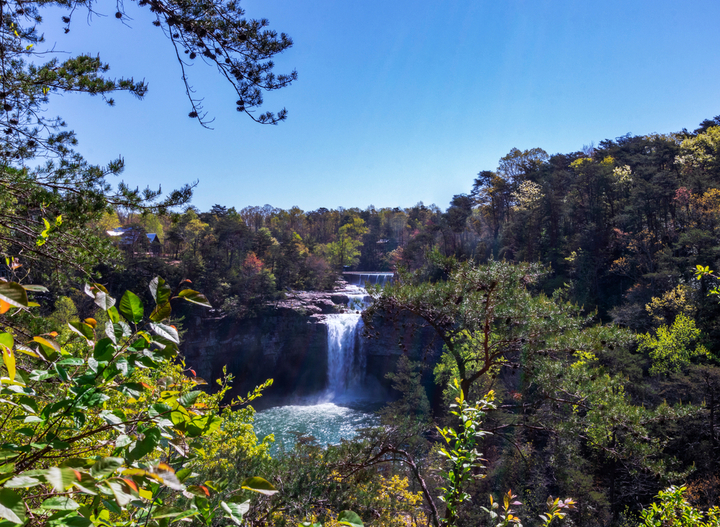
Little River Canyon National Preserve
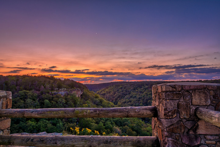
The Little River Canyon National Preserve is a United States National Preserve located in the Cherokee and DeKalb Counties. The preserve is 15,288 acres (61.87 km²). The Little River flows in this preserve and formed a Canyon. The river is known to be among the cleanest and wildest river in South of the U.S. The river has three major waterfalls: DeSoto Falls, Little River Falls and the seasonal Grace’s High Falls.
Russell Cave National Monument
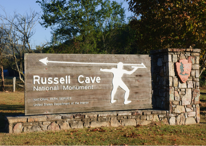
The Russell Cave National Monument is located northeast of Alabama close to the town of Bridgeport, in the Jackson County. The Russell Cave is exceptional by his very large main entrance and it was used as a shelter by prehistoric Indians for thousands of years.
Selma to Montgomery National Historical Trail
The Selma to Montgomery National Historical Trail is also a commemoration of the racial segregation in this part of the U.S. The trail is 54 mil (87 km) and it commemorates the Selma to Montgomery marches that happens in 1965 to support the Voting Rights Acts that prohibits the racial segregation.
Tuskegee Airmen National Historic Site

This historical site is located in the city of Tuskegee in the Macon County. This site commemorates the primary flight training site of African-American airmen in the World War II
Tuskegee Institute National Historic Site
This site, also called the Tuskegee University, is a private University that has played a big role in the higher education of African-American.
National Forests
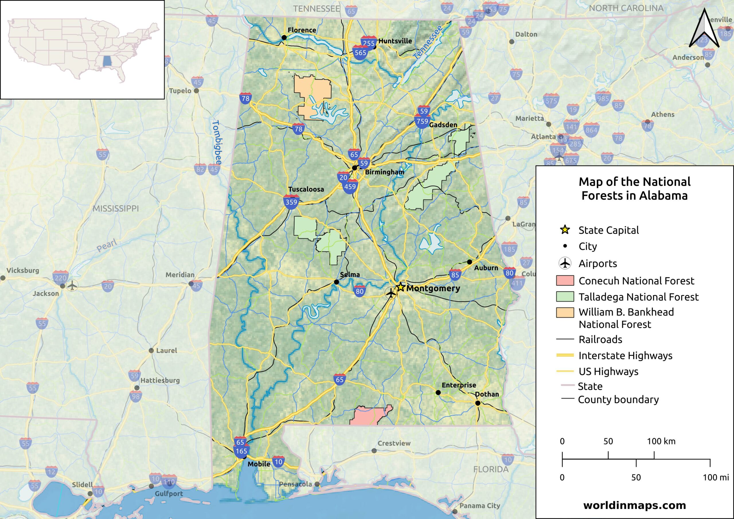
The state of Alabama has also 3 National Forests: Conecuh National Forest, Talladega National Forest and William B. Bankhead National Forest.
Must see in Alabama

Birmingham ***
Birmingham Museum of Art ***
The Birmingham Museum of Art has one of the most impressive collections int the Southeastern United States of paintings, sculptures… of different cultures, including African, American, Asian, European, Native American and Pre-Columbian. Among other is the collection of Asian art of particular interest.
Birmingham Civil Rights Institute **
The Birmingham Civil Rights Institute is a museum and research center dedicated on the Civil Rights Movements of the 1950s and 1960s that fight to end the racial segregation.
Birmingham Zoo **
The zoo of Birmingham is small in comparison to big city zoos, but has a wide variety of animals with approximately 550 animals of 195 species, which include among others sea lions, rhinos, elephants and lions.
Cathedral Caverns State Park ***
Cathedral Cavern was originally called the Bat Cave, but was renamed because of its cathedral-like appearance. Cathedral Caverns has many amazing features that are really unique. Its huge opening measures 126 feet (38,4 m) wide and 25 feet (7,6 m) high, which make it very unique. The cave is considered to have the largest stalagmites in the world with 45 feet (13,7 m) tall and 243 feet (74 m) in circumference.
Gulf State Park ***
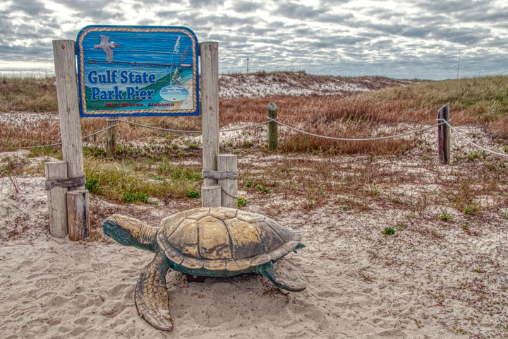
Gulf State Park is the place to visit for great outdoor vacations. The park is located on the Gulf of Mexico and is composed of a large beach area, marshland, boggy streams, pine forest and spring-fed, freshwater, lakes.
Little River Canyon National Preserve ***
Like is name let it understand this National Preserve is composed of a Canyon, but it has also 3 waterfalls. The DeSoto waterfall located in the DeSoto State Park is worth the walk. More information in the protected area section.
U.S. Space and Rocket Center ***
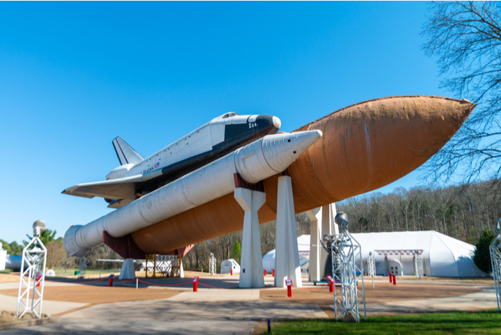
The U.S. Space and Rocket Center is a museum showcasing rockets, achievements and artifacts of the U.S. space program. The place is really a must to visit for anyone who is interested in space and rocketry.
Oak Mountain State Park **
The Oak Mountain State Park is located around 20 miles (32 km) south of Birmingham and it is the largest park in the state. The park has gorgeous views and includes a lot of activities like, among others, horseback riding, golf, kayak, paddle and swimming area.