Home / countries / Netherlands / Geography
Geography of the Netherlands
Where is the Netherlands located on the world map?
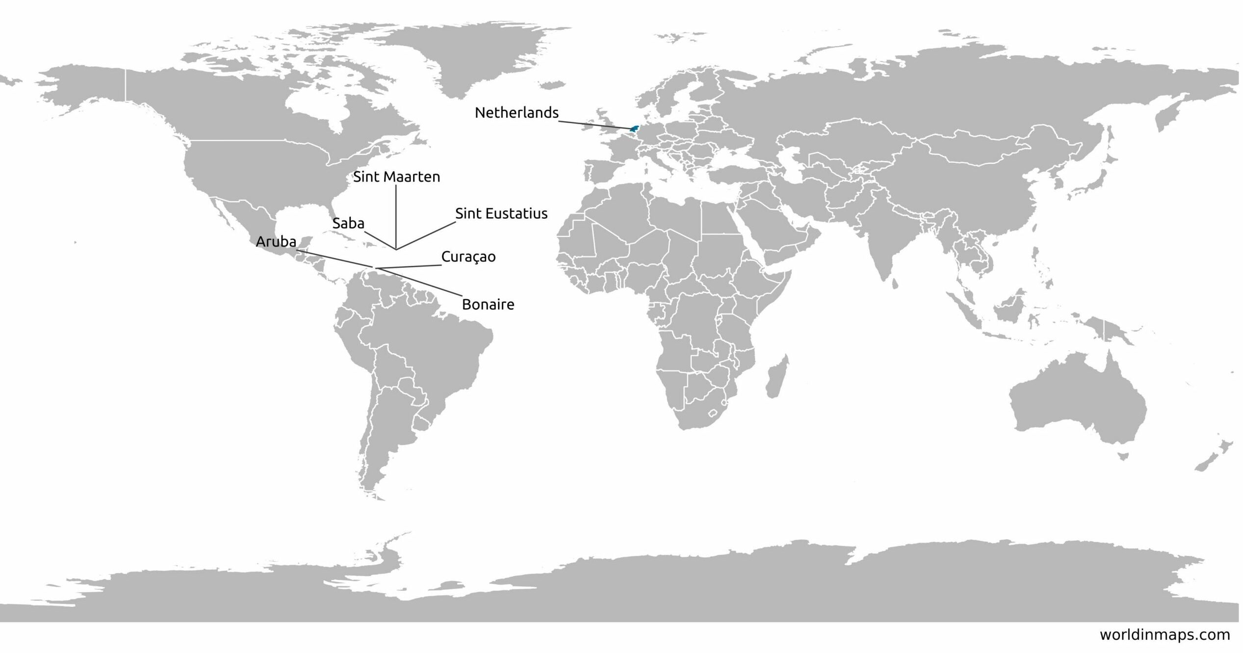
The Netherlands is a transcontinetal country whose metropolitan territory is located in Western Europe. The European territory has 12 provinces and 3 municipalities with a special status that are located overseas (Bonaire, Saba and Sint Eustatius). The Netherlands has also 3 autonomous territories in the Caribbean : Aruba, Curaçao and Sint Maarten.
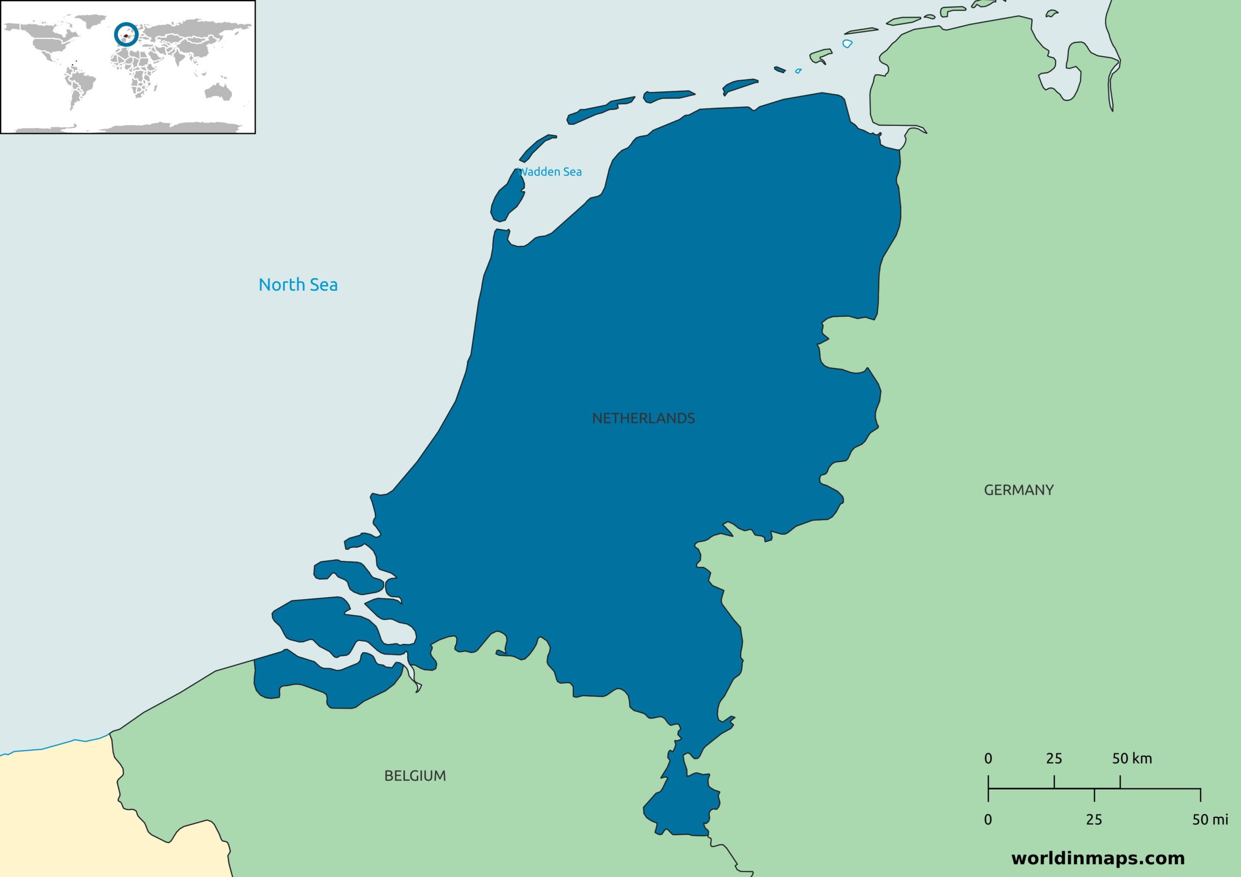
The European territory of The Netherlands has common borders with Belgium to the south and Germany to the east. At the west and the north, the country is limited by the north sea. The Netherlands has also a common border with France on the island of Sint Maarten in the Caribbean.
Map of the Netherlands

Geographical features
| Land area | 33 893 km² |
| Water area | 7 650 km² |
| Total area | 41 543 km² |
| Mean elevation | 30 m |
| Lowest Point | |
| Zuidplaspolder | -7 m |
| Highest point | |
| Mount Scenery (island of Saba in the Caribbean) | 862 m |
| Vaalserberg (continental Netherlands) | 322 m |
The country has a unique geographic feature, it has one of the lowest average altitude in the world. It is from this characteristic that the country gets his name. Around 25% of the European territory of the Netherlands is located below the level of the North sea. Around 18% of the continental part of the country is also covered by water. One of the main feature of The Netherlands is also their conquest on water with 17% of the territory that are polders.
Land use
The land use in the Netherlands for 2011 was the following:
| Arable land | 29.8% |
| Permanent crops | 1.1% |
| Permanent pasture | 24.2% |
| Agricultural land | 55.1% |
| Forest | 10.8% |
| Other | 34.1% |
The Netherlands has held a very high proportion of agricultural land area. They were able to hold the agricultural area by winning land on the sea, with the creation of polders, through the centuries and by a very strict urbanization policy. The Netherlands is the second food exporter in the world. However, the proportion of the agricultural workforce is very limited (around 1%) due to the high mechanization of the agriculture.
Urbanization
The level of urbanization of the Netherlands is very high with 92.2% of the population that live in an urban area in 2020. The annual rate of change between 2015 and 2020 was 0.74%.
Administrative divisions
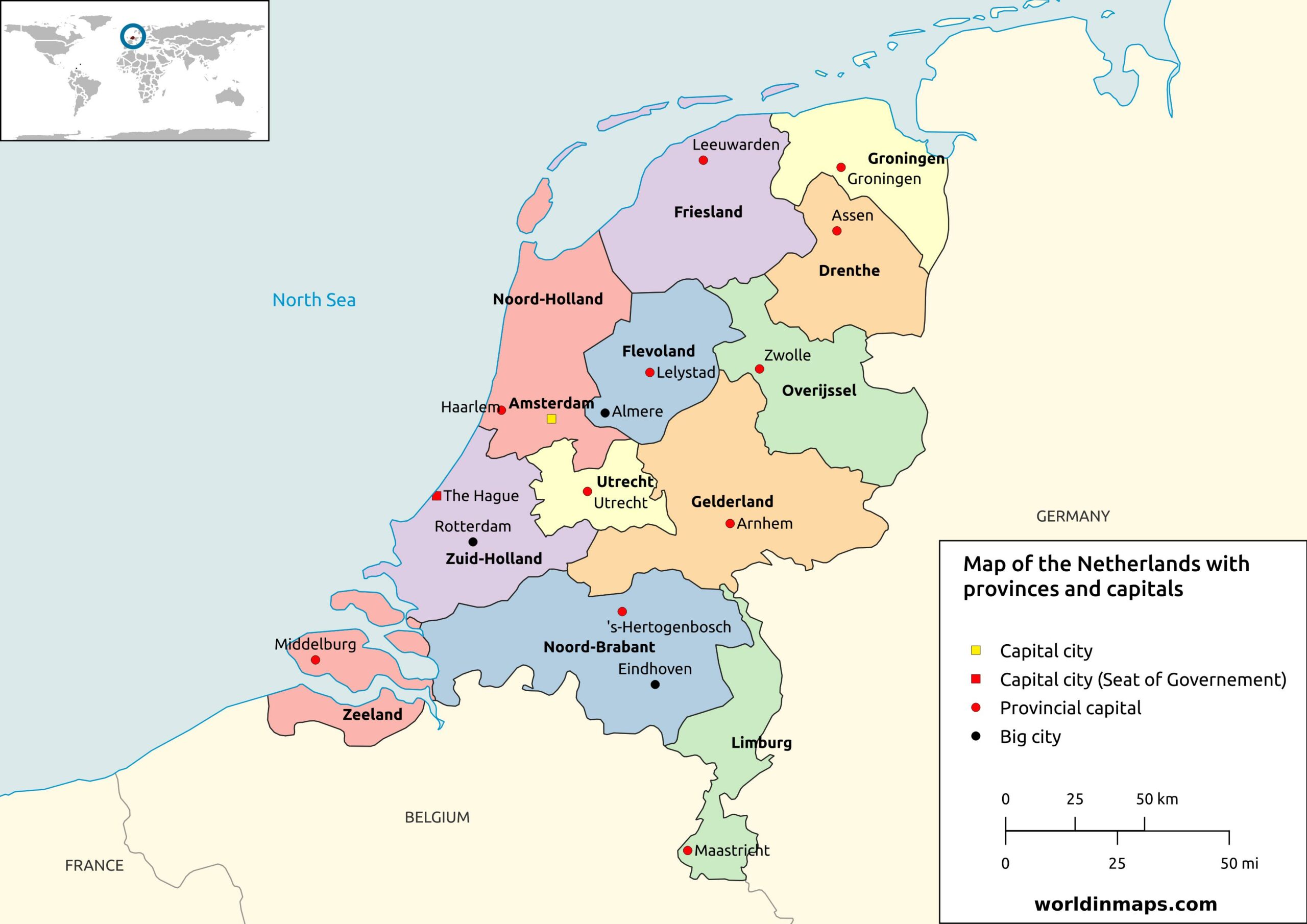
The Netherlands is divided into 12 provinces. These are divided into 345 municipalities. Next to these provinces on the European continent, the Netherlands has 3 islands in the Carribean that are “special municipalities”. The 3 autonomous regions of Aruba, Curaçao and Sint Maarten are part of the Kingdom of the Netherlands, but are separated entities from The Netherlands and its administrative divisions.
Provinces
| Province | Capital | Largest city | Total area | Land area | Population (2019) | Density |
|---|---|---|---|---|---|---|
| Drenthe | Assen | Emmen | 2 680 km² (1 030 sq mi) | 2 634 km² (1 017 sq mi) | 493 449 | 188 inhabitants / km² (490 inhabitants / sq mi) |
| Flevoland | Lelystad | Almere | 2 413 km² (932 sq mi) | 1 413 km² (546 sq mi) | 422 202 | 299 inhabitants / km² (770 inhabitants / sq mi) |
| Friesland | Leeuwarden | Leeuwarden | 5 749 km² (2 220 sq mi) | 3 324 km² (1 283 sq mi) | 649 988 | 196 inhabitants / km² (510 inhabitants / sq mi) |
| Gelderland | Arnhem | Nijmegen | 5 136 km² (1 983 sq mi) | 4 967 km² (1 918 sq mi) | 2 084 478 | 420 inhabitants / km² (1 100 inhabitants / sq mi) |
| Groningen | Groningen | Groningen | 2 960 km² (1 140 sq mi) | 2 325 km² (898 sq mi) | 585 881 | 252 inhabitants / km² (650 inhabitants / sq mi) |
| Limburg | Maastricht | Maastricht | 2 210 km² (850 sq mi) | 2 148 km² (829 sq mi) | 1 118 223 | 521 inhabitants / km² (1 350 inhabitants / sq mi) |
| North Brabant | ‘s-Hertogenbosch | Eindhoven | 5 082 km² (1 962 sq mi) | 4 908 km² (1 895 sq mi) | 2 562 566 | 523 inhabitants / km² (1 350 inhabitants / sq mi) |
| North Holland | Haarlem | Amsterdam | 4 092 km² (1 580 sq mi) | 2 662 km² (1 028 sq mi) | 2 877 909 | 1 082 inhabitants / km² (2 800 inhabitants / sq mi) |
| Overijssel | Zwolle | Enschede | 3 421 km² (1 321 sq mi) | 3 323 km² (1 283 sq mi) | 1 162 215 | 350 P / km² (910 P / sq mi) |
| South Holland | The Hague | Rotterdam | 3 419 km² (1 320 sq mi) | 2 814 km² (1 086 sq mi) | 3 705 625 | 1 317 inhabitants / km² (3 410 inhabitants / sq mi) |
| Utrecht | Utrecht | Utrecht | 1 449 km² (559 sq mi) | 1 380 km² (530 sq mi) | 1 353 596 | 981 inhabitants / km² (2 540 inhabitants / sq mi) |
| Zeeland | Middelburg | Middelburg | 2 934 km² (1 133 sq mi) | 1 783 km² (688 sq mi) | 383 689 | 216 inhabitants / km² (560 inhabitants / sq mi) |
Special municipalities
| Name | Capital | Area | Population | Density |
|---|---|---|---|---|
| Bonaire | Kralendijk | 294 km² (114 sq mi) | 20 104 | 69 inhabitants / km² (180 inhabitants / sq mi) |
| Saba | The Bottom | 13 km² (5 sq mi) | 1 915 | 148 inhabitants / km² (380 inhabitants / sq mi) |
| Sint-Eustatius | Oranjestard | 21 km² (8.1 sq mi) | 3 138 | 150 inhabitants / km² (390 inhabitants / sq mi) |
Major rivers
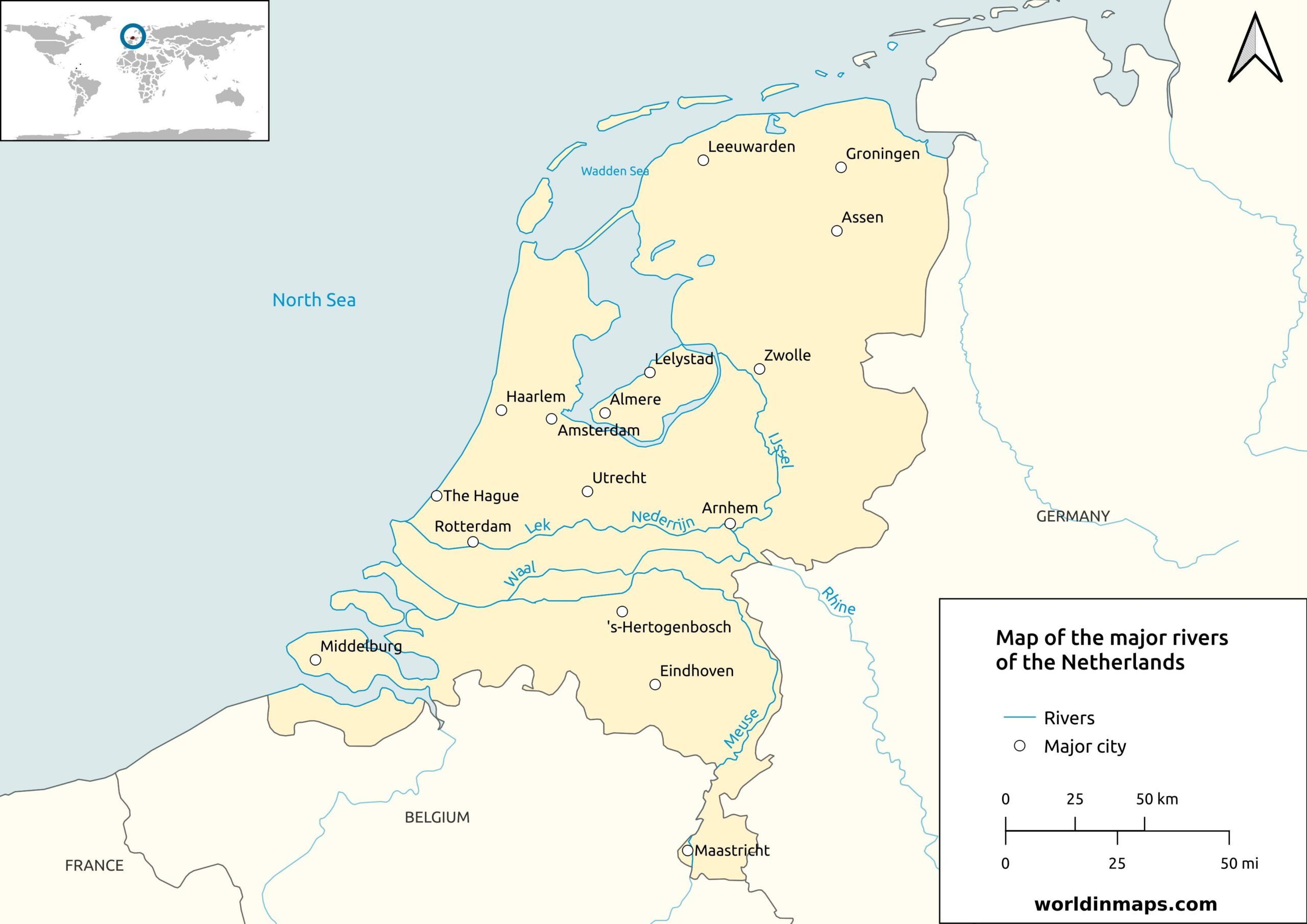
| River | Lengh | Drainage area | Mouth | Countries in the drainage basin |
|---|---|---|---|---|
| Rhine River | 1233 km (765 mi) | 220 000 km² | North Sea | Netherlands, Germany, France, Switzerland, Liechtenstein, Austria |
| Meuse River | 925 km (575 mi) | 34 548 km² | North Sea | Netherlands, Belgium, France |
| Scheldt River | 350 km (217 mi) | 21 860 km² | North Sea | Netherlands, Belgium, France |
| Ijsell River | 125 km (78 mi) | 4 271 km² | Ijsselmeer | Netherlands |
The Waal River and the Nederijn River (and further the Lek River) are part of the Rhine delta. Indeed the main branch of the Rhine River splits in 2 at that location.
The Scheldt Tiver flows trough France, Belgium and finally the Netherlands. The estuary of the Scheldt start in Belgium and so only the broad estuary of the Scheldt is located in the Netherlands.
A big part of the Netherlands is located in the Rhine-Meuse-Scheldt delta. The networks of these rivers are very complex with numerous branching.