The Rhine River
The Rhine River is one of the major rivers of Europe with its length of 1 230 km (760 mi). The river has also a very important role in the European economy. It is located in the center of the European Megalopolis (also known as the Blue Banana) and it is a very important artery transport. This is clearly highlighted with the port of Rotterdam (the largest European port and the 10th in the world) and the port of Duisburg which is the largest fluvial port in the world. The Rhine has also an important political and historical role.
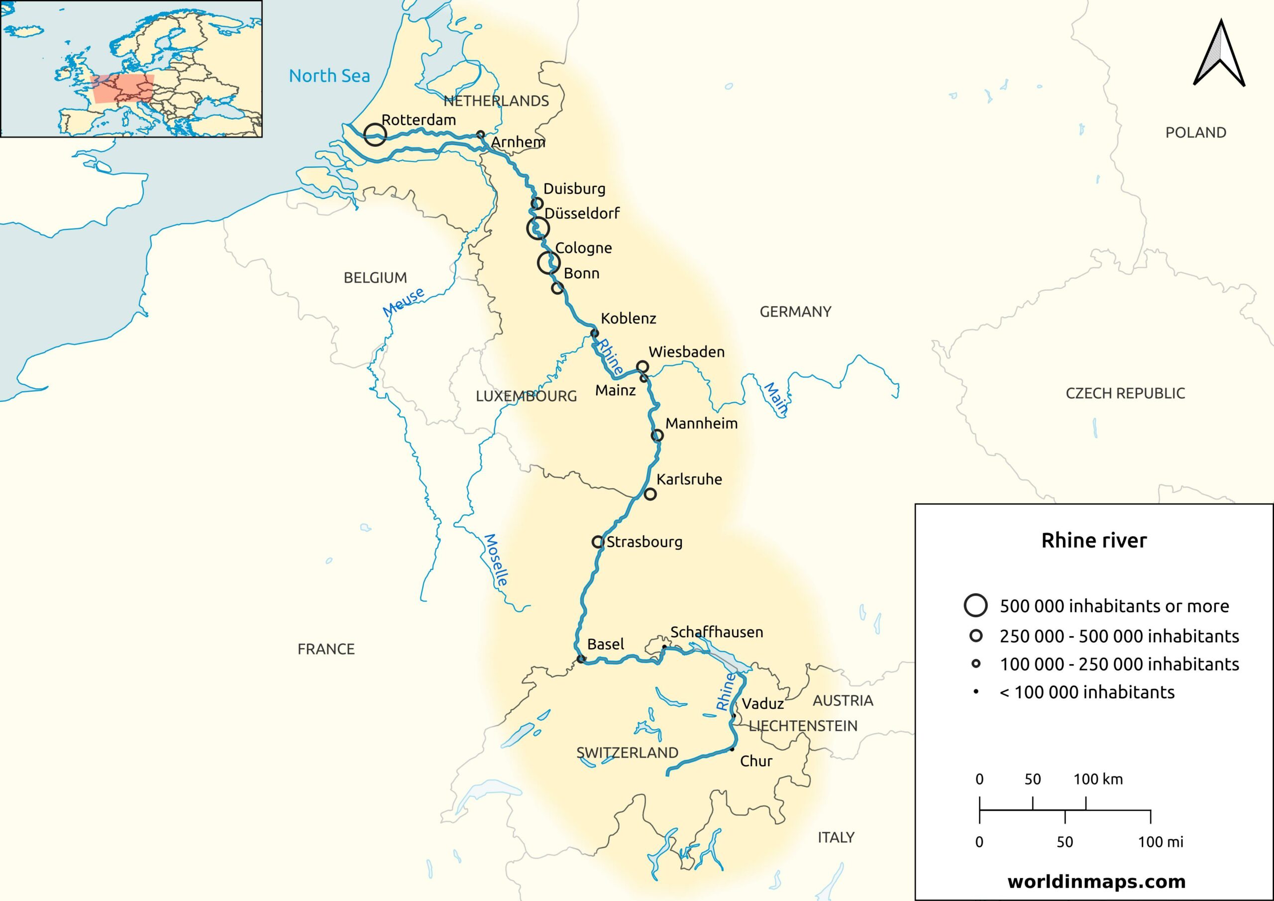
Rhine River map
Where is the Rhine River located?
The Rhine is one of the major rivers of Europe. It is located in western and central Europe and it is the second longest river in this part of Europe after the Danube, and it is the 11th longest in all Europe large after the Volga and the Danube that are on the top of this ranking. The Rhine has also an important geopolitical influence in Europe and define numerous borders. These borders are between Switzerland and Liechtenstein, Switzerland and Austria, Switzerland and Germany, France and Germany.
What countries does the Rhine flow through?
The Rhine flows from its source to its mouth through Switzerland, Liechtenstein, Austria, Germany, France and Netherlands. If we take the all Rhine Basin, above the country listed before we have Italy, Luxembourg and Belgium that have water flowing into the Rhine.
Key facts
| Countries | Switzerland, Liechtenstein, Austria, Germany, France and Netherlands |
| Major cities | Basel, Strasbourg, Bonn, Cologne, Düsseldorf, Duisburg and Rotterdam |
| Main source | Rein Anteriur / Vorderrhein |
| Location | Tomasee (Switzerland) |
| Elevation | 2 345 m (7 694 ft) |
| Secondary source | Rein Posteriur / Hinterrhein |
| Location | Paradies Glacier (Switzerland) |
| Elevation | 2 400 m (7 900 ft) |
| Confluence of the sources | |
| Location | Tamins (Switzerland) |
| Elevation | 585 m (1 919 ft) |
| Mouth | North Sea |
| Location | Meuse and Rhine delta (Netherlands) |
| Elevation | 0 m (0 ft) |
| Length | 1 230 km (760 mi) |
| Basin size | 185 000 km² (71 000 sq mi) |
| Discharge | |
| Average | 2 900 m³/s (100 000 cu ft/s) |
| Minimum | 800 m³/s (28 000 cu ft/s) |
| Maximum | 13 000 m³/s (460 000 cu ft/s) |
Geography of the Rhine
The Alpine Rhine flows from the source in the Swiss canton of Grison until the waterfalls of Schaffhouse, which are one of the biggest waterfalls of Europe. From these waterfalls begin the High Rhine until Basel. Then begin the Upper Rhine that forms the border between France and Germany. The Middle Rhine section is located between Bingen (located between Main and Koblenz) and Bonn. Then begin the Lower Rhine until in the Netherland and Finally the Nederrijn (or Nether Rhine).
The Rhine Falls
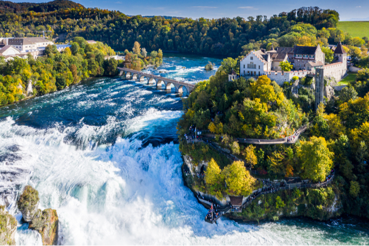
The Rhine Falls (Rheinfall in German) is the name of the waterfalls located near Schaffhouse. These waterfalls have a total height of 23 m (75ft) and 150 m (490 ft) in width and give an impressive sight. But the waterfalls are more famous for the huge amount of volume of water passing through them, with a volume that varies between 250 m³/s (8 800 cu ft/s) in the winter and 600 m³/s (21 000 cu ft/s) during the summer. This makes them the most powerful waterfalls in Europe.
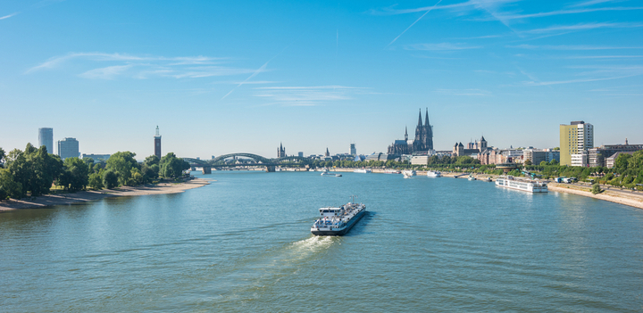
Major cities on the Rhine river
The Rhine River is of a very important economic importance in Europe and it is not surprising to have very large cities located on the Rhine. The largest ones are Basel, Strasbourg, Cologne, Düsseldorf and Rotterdam.
Economic importance of the Rhine
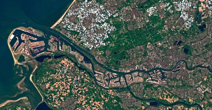
The Rhine River is the backbone of the Rhineland Europe. This region corresponds geographically to the basin of the Rhine, the Meuse and the Scheldt, which are connected in a common delta. This region is the most dynamic economic area in Europe and one of the great places of power in the world. The Rhineland Europe is the central part of the larger European Megalopolis (also known as the Blue Banana) that extend from London to Milan. The Rhine basin with its 185 000 km² holds a population of around 50 million people.
The Rhine is navigable between the cities of Bale and Rotterdam (which is the first European port). 320 Million of tonnes transit on the Rhine each year with coal, iron, food products, petrochemical products,… but also containers coming from everywhere in the world.
The Rhine is not more only a European transport artery, but more and more it becomes global by becoming an important communication artery in the link between Germany (the first European economy) and China (the second economy in the world). Duisburg is the first fluvial port in the world and it is going to become a strategic point in the New Silk Roads. Indeed, Germany and the China’s maritime transport giant Cosco are finishing a new terminal that will become the largest terminal for ships, trucks and trains of Europe. This new terminal will distribute to the neighboring countries around 850 000 containers coming from China each year.
Rhine wines
The Rhine River is also known for its wines and it has given the name to the Rhine Wines. These wines are all the wines produced along the Rhine River. We found in these regions the Alsace in France and the Nahe, Rheinhessen, Mosel, Pfalz and Baden in Germany. The wines of the Rhine valley are often medium dry white wines.
Castles on the Rhine River
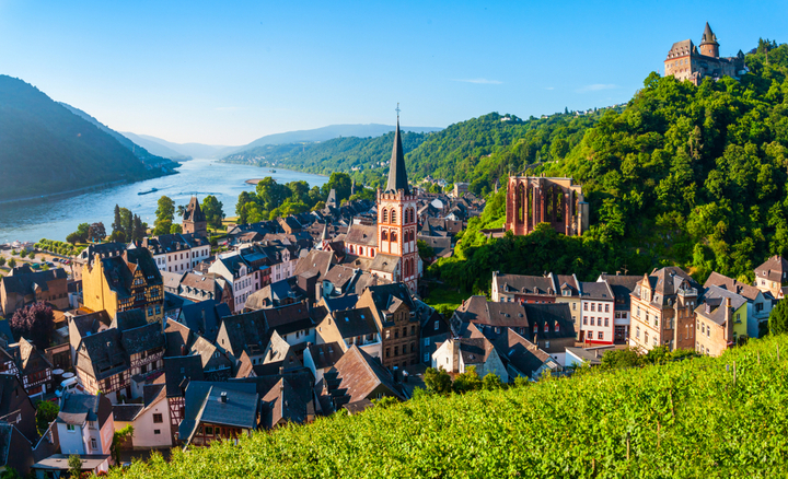
The 68 km of the Middle Rhine valley located between Bingen and Koblenz is listed on the UNESCO World Heritage Site because of its more than 40 castles and fortresses from the Middle Ages. With its steep slopes, steep valleys, strange rocks, vineyards and enchanting castles, this part of the Rhine looks very romantic and it is because of this that it is called the Romantic Rhine.