Geology | Home / Earthquakes
Earthquakes
An earthquake is the shaking of the surface of the Earth resulting from a sudden release of energy in the Earth’s lithosphere that creates seismic waves. This release of energy takes place by rupture along a fault, generally pre-existing. More rarely they are due to volcanic activity or of artificial origin (explosions for example).
Geological interactive world map
Discover and interact with all the last 30 days earthquakes, volcanoes, tectonic plates and their boundaries with our interactive world map or explore our guide for the map explorer.
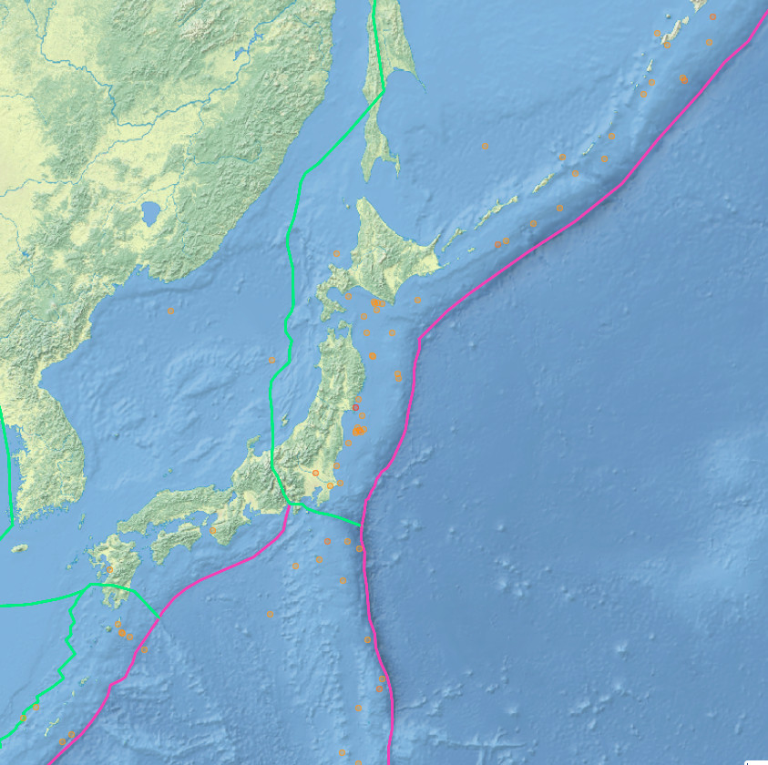
Recent earthquakes
Table of contents
- What causes earthquakes
- Tectonic earthquakes
- Earthquakes of volcanic origin
- Main features of an Earthquake
- Types of seismic waves
- Measuring of earthquakes (Magnitude)
- Frequency and effects
- Largest earthquakes since 1900
What causes Earthquakes
An earthquake is a more or less violent shaking of the ground which can have four origins:
- rupture of a fault or a segment of fault (tectonic earthquakes)
- intrusion and degassing of a magma (volcanic earthquakes)
- “Cracking” of ice caps echoing through the earth’s crust (polar earthquakes)
- explosion, cavity collapse (earthquakes of natural origin or due to human activity).
Tectonic earthquakes
Tectonic earthquakes are the result of movement along faults that suddenly release the stored elastic strain energy.
Most of the tectonic earthquakes takes place at the edges of the tectonics plates. Another part takes place along an existing or newly formed fragility plane.
Type of Earthquake faults
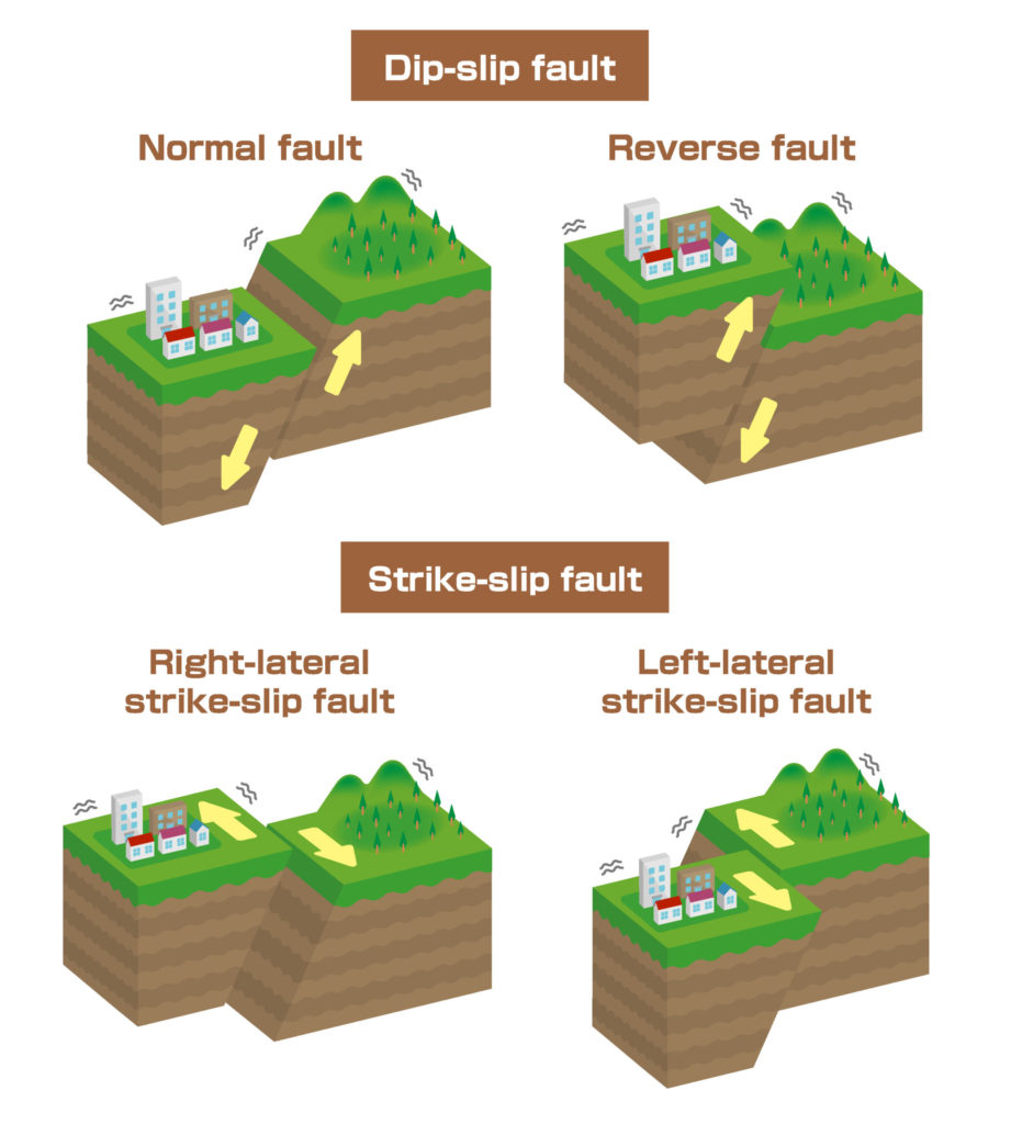
These faults are of three main types: normal, reverse and strike-slip.
Normal faults are dip-slip and so involve an vertical movement. In a normal fault, the block above the fault moves down relative to the block below the fault. Normal faults occur mainly in areas where the crust is being extended, like as in divergent boundaries. Earthquakes linked with normal faults have generally a magnitude less then 7. At the level of the mid-ocean ridges, earthquakes have superficial foci (0 to 10 kilometers), and correspond to 5% of the total seismic energy.
The reverse fault is the opposite of the normal fault, the block above the fault moves up relative to the block below the fault. Reverse faults occur in areas where the crust is being shortened like at convergent boundaries. These faults, particularly those along convergent plate boundaries are associated with the most powerful earthquakes. In subduction zones, earthquakes represent half of those that are destructive on Earth, and dissipate 75% of the earth’s seismic energy. It is the only place where we find deep earthquakes (from 300 to 645 km).
The Strike-slip fault is a steep structure where the 2 blocks move horizontally. Transform boundaries are example of strike-slip faults. These faults, particularly in transform boundaries, can produce major earthquakes, up to a magnitude of 8. at the level of large strike-slip faults, earthquakes occur with centers of intermediate depth (from 0 to 20 kilometers on average) which correspond to 15% of the energy.
Release of the accumulated energy does not usually happen in a single time, and it may take several readjustments before regaining a stable configuration. Thus, aftershocks are observed following the main shock of an earthquake, of decreasing amplitude, and over a period ranging from a few minutes to more than a year.
Intraplate Earthquake
Intraplate earthquakes are earthquake that occurs within the tectonic plate, in contrast with earthquakes at the boundaries of tectonic plates.
These earthquakes are rare compared to the earthquakes on the boundaries of the tectonic plates.
All tectonic plates have internal stress field caused by their interactions with neighboring plates, sedimentary loading or unloading (for example by deglaciation). The accumulation of these stresses may be release along existing fault plane and having has consequence intraplate earthquakes.
Earthquakes of volcanic origin
Earthquakes of volcanic origin result from the accumulation of magma in the magma chamber of a volcano. The seismographs then record a multitude of microseisms due to ruptures in the compressed rocks or to the degassing of the magma. The gradual rise of hypocenters (linked to the rise of magma) is an indication that the volcano is waking up and that an eruption is imminent.
Main features of an Earthquake
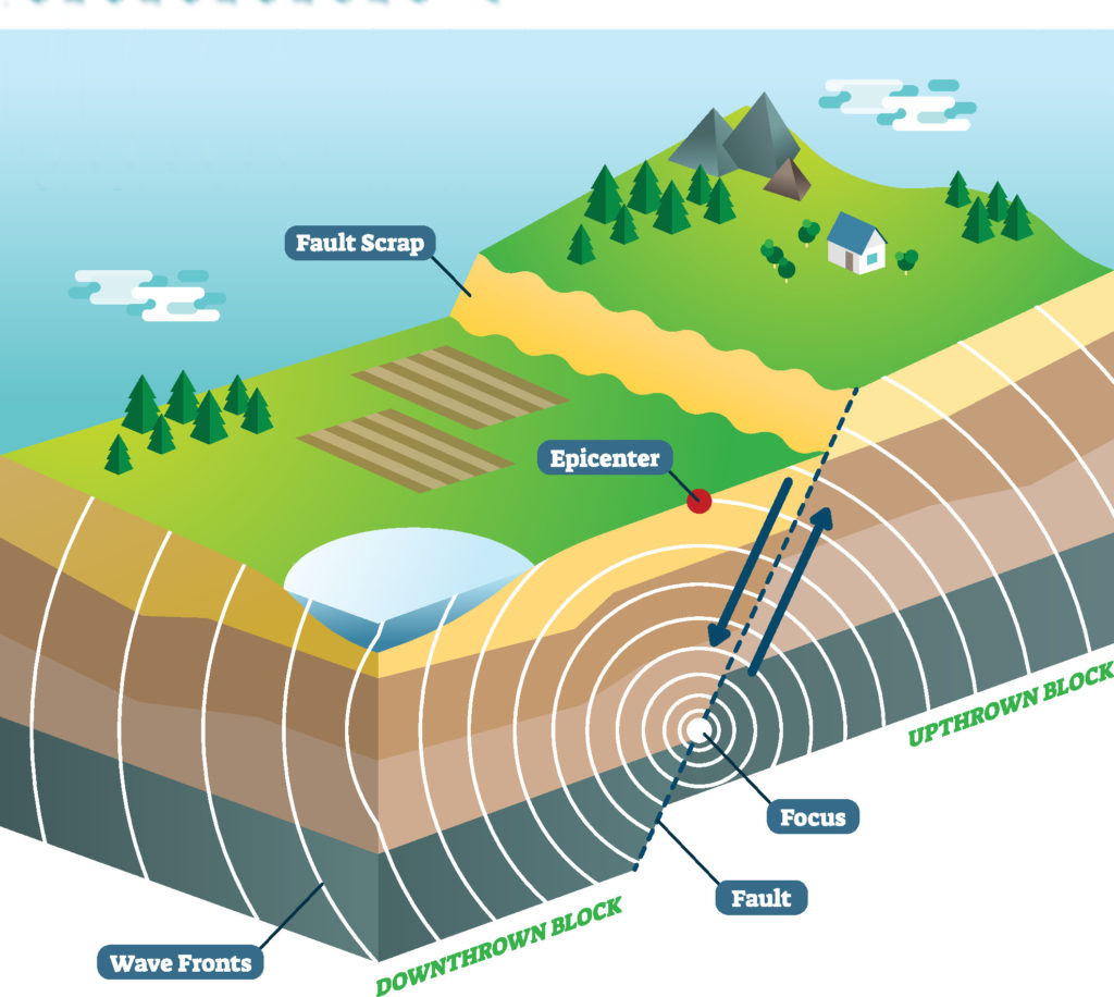
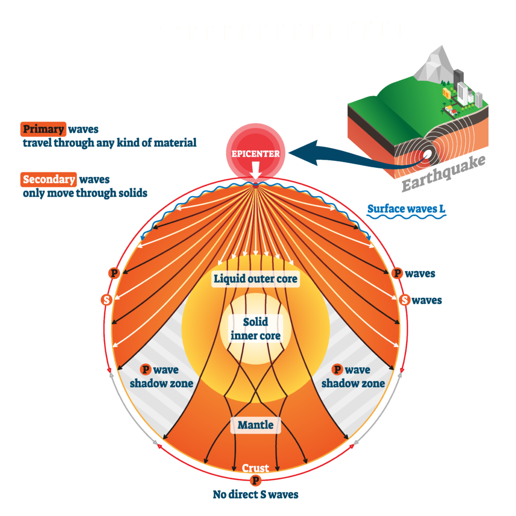
The hypocenter (or focus) is the point of initial rupture. It can be located between the surface and 670 km (420 mi), which is the limit between the upper and lower mantle.
The epicenter is the point on the surface of the earth directly above the hypocenter.
Types of seismic waves
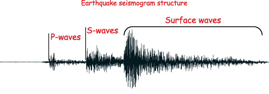
At the time of the sudden release of the constraints of the earth’s crust (earthquake), two main categories of waves can be generated. These are body waves that propagate inside the Earth and surface waves that propagate along the Earth’s surface.
Body waves
The body waves are divided in 2 types of wave as a result of 2 types of particle motion:
P-waves (Primary waves) or compression waves
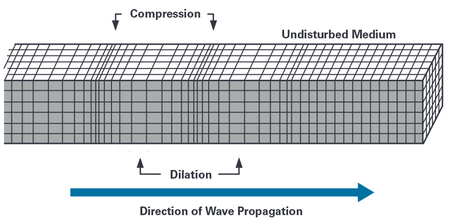
The ground is moved by successive expansion and compression, parallel to the direction of wave propagation. P waves are the fastest (6 km / s near the surface). So these are the waves recorded first on a seismogram and these wave can travel in any type of material (including fluids).
S-waves (Secondary waves) or shear waves
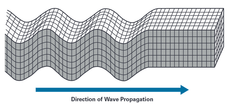
The vibrations are perpendicular to the direction of propagation of the wave. Slower than P waves, they appear second on seismograms. The S-wave are around 60% more slowly then the P-wave in any given material. The S-waves are not able to travel in liquid. Their absence in the earth’s outer core and so it suggests a liquid state.
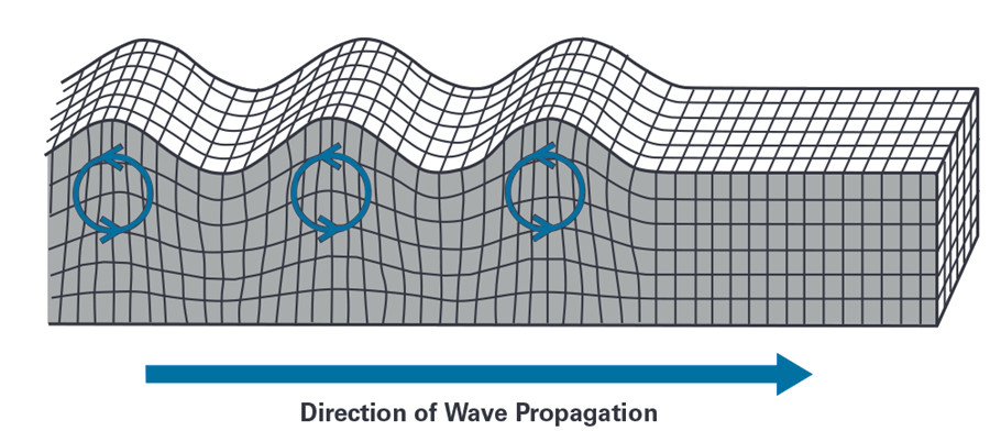
Surface waves
Seismic surface waves propagate along the Earth’s surface. They are more slowly than seismic body waves (P-waves and S-waves). They can reach an amplitude of several centimeters in big earthquakes and they are usually the waves responsible of the destructive effects of earthquakes.
We can distinguished 2 type of surface waves:
Rayleigh waves
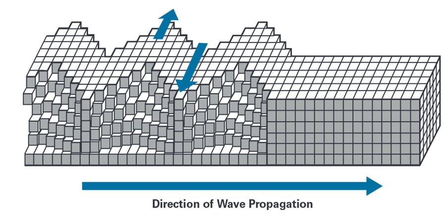
These waves includes both longitudinal and transerve motions that decrease exponentially in amplitude as distance from the surface increases. They are generated by the interaction of P-waves and S-waves. They are more slowly than P-wave and S-wave (around 90% of the velocity of S-waves)
Love waves
These waves are horizontally polarized surface waves. They are the result of the interference between many S-waves. They are slower than P- and S- waves, but faster than the Rayleigh waves.
Measuring of earthquakes (Magnitude)
The magnitude is in seismology the logarithmic representation of the seismic moment, which is itself a measure of the energy released by an earthquake.
The more energy the earthquake has released, the higher the magnitude: an increase in magnitude of 1 corresponds to a 30 times increase in energy and a 10 times increase in the amplitude of movement.
The media often use the term of Richter scale or open Richter scale, but these terms are not correct. Indead, the Richter scale is a local scale especially adapted to the Califonian earthquakes. The magnitudes usually cited nowadays are in fact moment magnitudes.
The following types of magnitudes are defined:
- Richter Scale or the local magnitude scale (ML or ML)
- mB scale that are calculated from body-wave
- MS scale that are calculated from surface waves.
- The moment magnitude scale (Mw) is based o an earthquake’s seismic moment.
Seismic magnitude scale and intensity scales are two different measures. Intensity is a measure of the damage caused by an earthquake. The intensity can have different values for the same earthquakes. Relationships between the maximum felt intensity and the magnitude exist but they are very dependent on the local geological context. These relationships are usually used to find the magnitude of historical earthquakes.
Frequency and effects
| Description | Moment magnitude scale | Effects | Global average frequency |
|---|---|---|---|
| Micro | < 1.9 | Micro earthquake, not felt. | 8,000 / day |
| Very minor | 2.0 – 2.9 | Usually not felt. | 1,000 / day |
| Minor | 3.0 – 3.9 | Often felt but without causing damage. | 50,000 / year |
| Small | 4.0 – 4.9 | Noticeable shaking of objects inside houses, clashing noises. The damage remains very light. | 6,000 / year |
| Moderate | 5.0 – 5.9 | Can cause significant damage to poorly designed buildings in restricted areas. No damage to well-constructed buildings. | 800 / year |
| Strong | 6.0 – 6.9 | Can cause serious damage for several tens of kilometers. Only adapted buildings resist near the center. | 120 / year |
| Very Strong | 7.0 – 7.9 | Can cause severe damage over large areas; all buildings are affected near the center. | 18 / year |
| Major | 8.0 – 8.9 | Can cause very severe damage in areas hundreds of kilometers around. Major damage to all buildings, including tens of kilometers from the center. | 1 / year |
| Near total destruction | 9.0 and more | Devastates areas for kilometers of miles around. Damage over 1,000 kilometers around. | 1 to 5 / century |
Largest earthquakes since 1900
| Magnitude | Date | Location |
|---|---|---|
| 9.5 | May 22, 1960 | Valdivia, Chile |
| 9.4 | December, 26 2004 | Sumatra, Indonesia |
| 9.2 | March, 27 1964 | Prince William Sound, Alaska |
| 9.1 | March, 11 2011 | Tōhoku region, Japan |
| 9.0 | November, 4 1952 | Kamchatka, Soviet Union |
| 8.8 | January 31, 1906 | Ecuador – Colombia |
| 8.8 | February, 27 2010 | Concepción, Chile |
| 8.7 | February, 4 1965 | Rat Islands, Alaska |
| 8.7 | March, 28 2005 | Nias Island, Indonesia |
| 8.7 | April, 11 2012 | Indian Ocean (between India, Indonesia, Sri Lanka and Thailand) |