Geology | Home / Tectonic plates and their boundaries
Tectonic plates and their boundaries
What are tectonic plates and what are the types of plate boundaries? This article will try to answer these questions by presenting the theory and the history of establishing this theory. Some diagrams and maps of the tectonic plates and their boundaries will help to visualise this concept. We will also see the cycle of Wilson that led to build supercontinents. In conclusion, we will list all the old supercontinents.
Geological interactive map
Discover and interact with all the tectonic plates and their boundaries with our interactive world map or explore our guide for the map explorer.
Table of contents
- Definition of the tectonic plates
- What is the lithosphere?
- History
- List of Majors tectonic plates
- List of Minors tectonics plates
- The current model of the tectonic plates
- Type of tectonic plates boundaries
- Wilson cycle
- List of supercontinents
- The next supercontinent
Definition of the tectonic plates
The word is coming from the Late Latin: tectonicus that come himself from the Ancient Greek τεκτονικός (pertaining to building).
The plate tectonics is a scientific theory that explains the global dynamics of the Earth’s lithosphere.
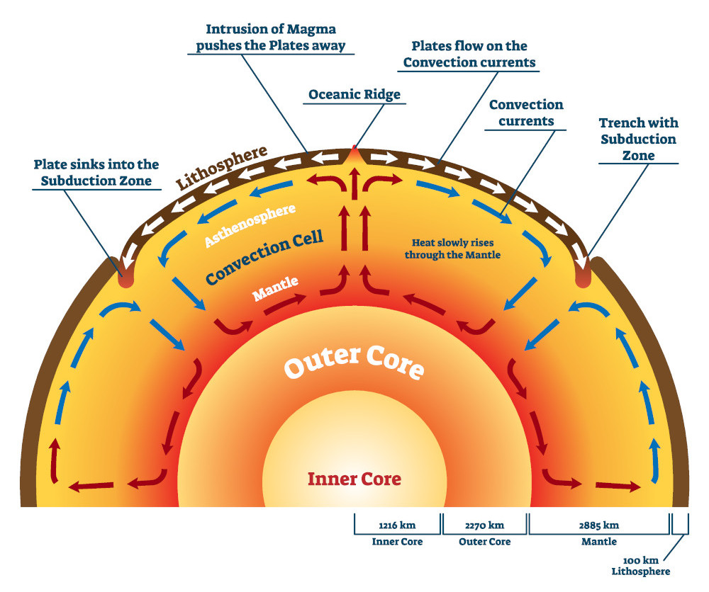
At the start of the 20th century, Alfred Wegener developed the concept of continental drift, which led as a result to the theoretical model of the plate tectonics. However, it is only in the 1960’s that the international geological community accepted the theory of plate tectonic. They accepted the theory after the discovery of the concept of the mantle convection current.
What is the lithosphere?
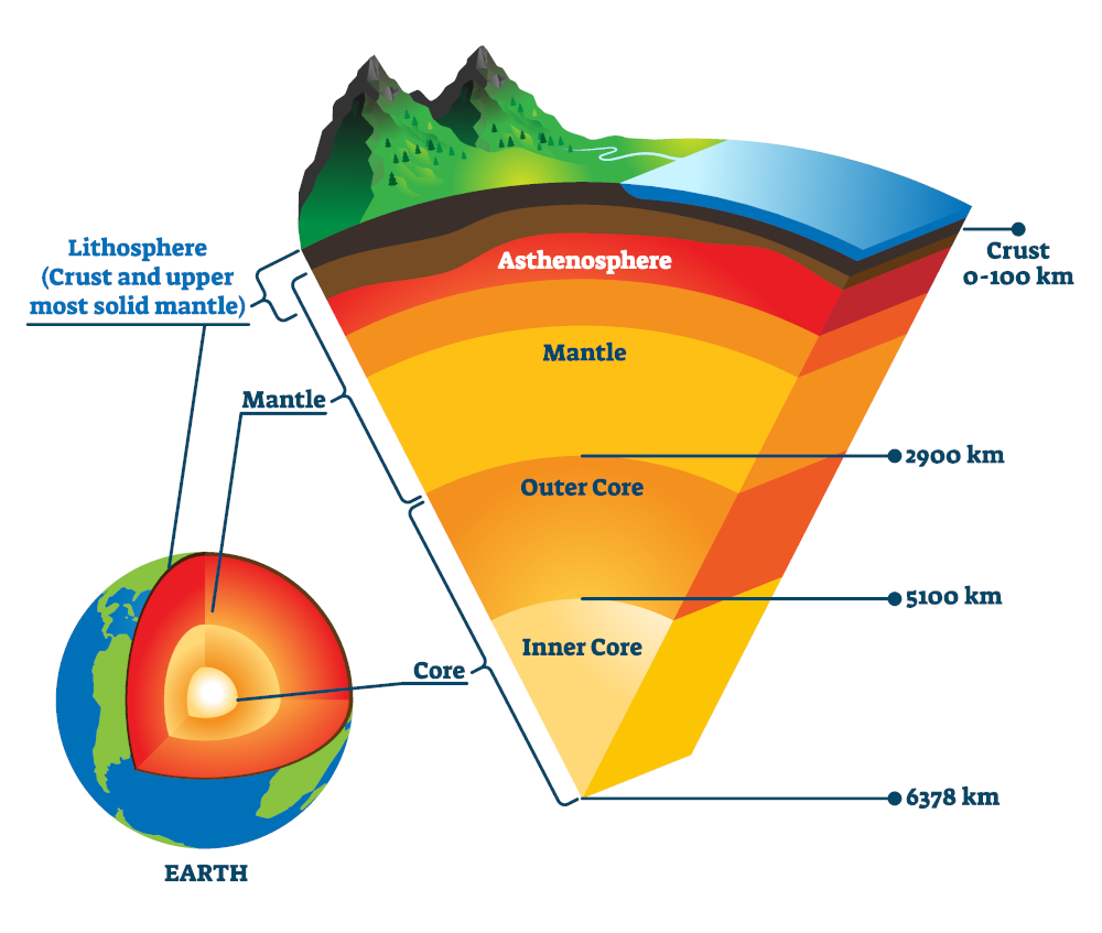
The lithosphere is the outermost part of the earth structure. So, it consists of the crust and a small portion of the upper mantle. The lithosphere is divided into pieces called tectonic plates. These plates move and interact with one another, driven by the convection current of the mantle.
History
Continental drift
For several centuries, the “fixist theory” dominated the earth sciences. In short, this theory is based on the observation of the solid state of almost all of the terrestrial globe and of the terrestrial surface which presents an unchanging, stable geometry.
In 1596, the Flemish cartographer Abraham Ortelius published his books “Thesaurus Geographic” with observations about the similar shapes of the American and African coasts. He supposes that these 2 continents were once united and that they were separated due to disasters: floods and earthquakes. Later theories went even further by admitting that this separation have happened during the flood myth and that this affirmation could be found in the book of genesis of the Bible.
Until the late 19th and early 20th centuries, geologists assumed that the Earth’s features were fixed. Only vertical crustal movement explained the features like basin development, volcanoes and mountain ranges. Again, different theories were existing to try to explain this vertical movement. Generally, scientists considered that contraction of the planet due to heat loss caused the vertical crustal movements.
Alfred Wegener

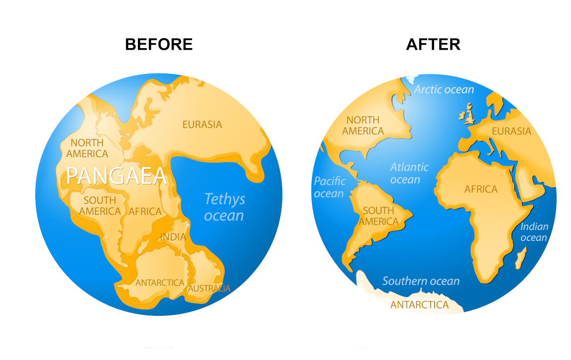
On January 6, 1912, the German meteorologist Alfred Wegener presented to the Geological Society of Frankfurt am Main a coherent and argued presentation of the theory of continental drift, with several elements of demonstration. Other scientists before him have argued the theory of continental drift, but het was the first to give elements of demonstration. For him, a supercontinent Pangea (derived from Ancient Greek pan (πᾶν, “all, entire, whole”) and Gaia (Γαῖα, “Mother Earth, land”)) broke up at the beginning of the secondary era. This causes the opening of the North Atlantic, the separation of Antarctica and then the opening of the South Atlantic. Since this era, the continental masses resulting from this fragmentation are drifting on the surface of the Earth like rafts.
In 1915, he published the Origin of Continents and Oceans. In this book, he specified the numerous proofs on which he relies:
- Morphological evidence (interlocking shapes of continents such as the northeastern horn of Brazil and the bottom of the Gulf of Guinea)
- Stratigraphic (stratigraphic continuity between Africa and South America)
- Paleaoclimatic (striated pebbles dating from the Primary in South Africa and South America, which testifies that the two continents underwent the same glacial influences during the Paleozoic era)
- paleontological (same fauna and flora of the primary among which the mesosaurs, cygnonatus and glossopteris)
However, many geologists rejected his ideas. Indeed, Alfred Wegener fails in his theory to provide a plausible cause of this drift. As a result, Geologists did not see how continental rock could “plow through” the much denser rock that makes up oceanic crust. Alfred Wegener could not explain the force that drove continental drift. This explanation did not come until after his death in 1930.
Theory of the mantle convection
During the thirties up to the late fifties, numerous scientists outlined concepts close or nearly identical to the modern plate tectonics theory. In particular the English Geologist Arthur Holmes. He proposed in 1920 that plate junctions might lie beneath the sea. In 1944, he suggested in his book “Principle of Physical Geology” that convection currents within the mantle might be the driving force. These contributions had not real impact due to several factors:
- continental drift was still not accepted
- it was published in extreme political and economic instability that hindered scientific communication
- many were published by European Scientists and at first not mentioned or given little credit in the papers on about the spreading of the sea floor published by American scientist in the 1960
Mid-oceanic ridge spreading
In 1947, a team of scientists lead by Maurice Ewing confirmed the existence of a rise in the Central Atlantic Ocean. They also discovered that the floor of the seabed under the layer of sediments was made of basalt. It was not granite which is the main constituent of continents. They also observe that the oceanic crust was much thinner than the continental crust.
After this major outcome, scientists discovered a system of mid-oceanic ridges all along the globe. So, this was a huge discovery that led to the conclusion that along this system, new ocean floor was created. One question was still remaining: the ridge created continuously new crust, but the size of the earth is not changing. This question had already been solved by scientist during the forties and fifties: the crusts in excess disappear along “oceanic trenches” (where subduction occurs).
In 1962, the American geologist Harry Hess relies on new scientific data (ocean floor maps with evidence of ocean rifts, trenches, heat fluxes and maps of the age of the ocean floor) to develop a new scientific model. As a result, he arrived at the same conclusion as Holmes. So, if the Earth’s crust was expanding along the ridges it must be shrinking elsewhere. So, he suggested that new oceanic crust continuously spreads away from the ridges and finally they descend along the continental margins where they form oceanic trenches (very deep narrow canyons). Like Holmes, he suggested that convection currents are the driving force of this process. Harry Hess also concluded that the Atlantic Ocean was expanding while the Pacific Ocean was shrinking.
This concept of old oceanic crust consumed in the trenches and new magma rising in the spreading ridges, to form new crust, explain why the earth does not get bigger with the sea floor spreading. But it also explains why there is so little sediment accumulation on the ocean floor and why oceanic rocks are much younger than continental rocks. Indeed, the ocean basins are perpetually recycled.
Magnetic striping
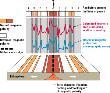
In the 1950s, scientists using magnetometers began to recognize odd magnetic variations across the ocean floor. The ocean floor is made of basalt. This volcanic rock is rich in iron and it contains a strongly magnetic mineral (magnetite). This mineral can even locally distort compass reading. When newly formed rock cool down such magnetic minerals record the Earth’s magnetic field at the time that they solidified. This gave a new very interesting study field.
In the 1950’s, scientists mapped more and more of the sea floor. While they mapped the sea floor the variation start to show recognizable patterns. The ocean floor shows a zebra-like pattern with alternating normal polarity and the adjoining stripe with reversed polarity. Ron G. Mason and his team published this magnetic striping in 1961.
In 1963, Drummond Matthews, Fred Vine and Lawrence Morley made the link between this magnetic striping and the sea floor spreading. They also linked the phenomena with the geomagnetic reversals of the Earth. They also put in evidence that these magnetic striping were symmetric around the crests of the mid-ocean ridges. Therefore, the youngest rocks (at the ridge crest) always have present-day (normal) polarity of Earth magnetism. The stripes of rock parallel to the ridge crest alternate in magnetic polarity. So, this suggests that they were formed at different epochs and that it is a natural “tape recording” of the history of the geomagnetic field reversals (GMFR) of the Earth’s magnetic field.
Definition of the theory of the tectonic plates
The plate tectonics theory modelled the relative movements of the tectonic plates. It was set up to give a global explanation to the sea floor spreading and the seismicity of the oceanic trenches. The scientific community quickly accepted the theory because of all the evidence and discoveries. Finally, new discoveries led to add new concepts to this theory.
In 1965, Tuzo Wilson added the concept of transform faults to the model. This type of fault completes the classes of fault types (normal and reverse). These are necessary to make the mobility of the plates on the globe work out.
In 1968, William Jason Morgan suggested that 6 big plates and 12 more little one modelled the tectonic plates theory. The same year, Xavier Le Pichon proposed a model compose of 6 plates and he has shown their movements since 120 million years.
Finally, Jack Oliver and Bryan Isacks could explain the global seismicity with the model of the plate tectonics. This convinced the last skeptical scientists.
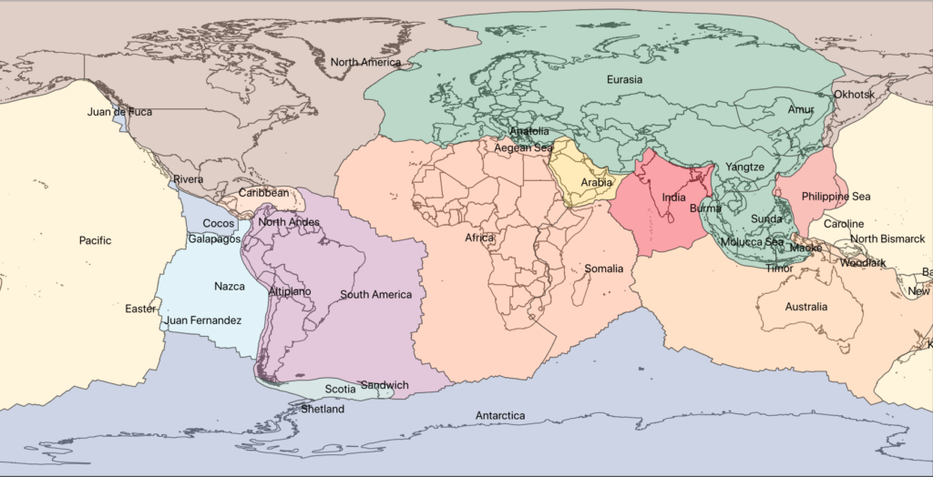
List of Majors tectonic plates
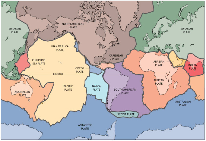
Nowadays, it is admitted that there is 7 to 8 major plates:
- African
- Antarctic
- Eurasian
- North American
- South American
- Pacific
- Indo-Australian
The latter is sometimes subdivided into the Indian and Australian plates.
These major plates cover 94% of the earth.
List of Minors tectonic plates
Between this 7 to 8 major plates, there are 46 little plates. The 7 largest of which are:
- Arabian
- Caribbean
- Juan de Fuca
- Cocos
- Nazca
- Philippine Sea
- Scotia
The current model of the tectonic plates
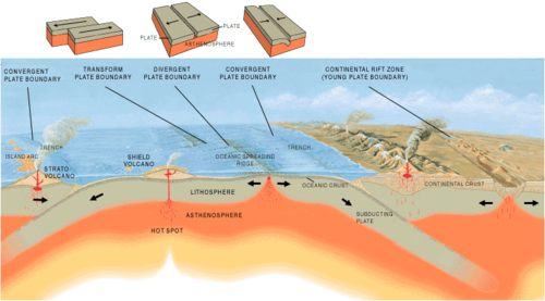
Nowadays, it is accepted that the movements of the underlying Astenospheric mantle is driving the tectonic plates. These plates undergo 3 main types of interactions which define 3 types of boundaries: divergent, convergent and transform.
These 3 types of interactions are also linked to 3 big categories of faults:
- Normal fault is divergent (extensions)
- Reverse fault is convergent (compression)
- Transform fault (transform interaction)
Types of tectonic plates boundaries
Divergent tectonic plates boundaries (extension – constructive)
Continental rift
A zone of divergence appearing in a continental crust temporarily leads to the formation of a rift. An active rift in the continental zone cannot be a prolonged situation, because the separation of the two edges of the continental crust creates a void that will be filled with oceanic crust. This will finally create a new ocean.

The most famous example of a continental divergence area is the Great Rift Valley in Africa. This area is separating the African plate from the Somali plate. This rift extends until the already largely submerged Red Sea rift, which separates the African plate from the Arabian plate.
Oceanic spreading ridge
When the separation of the continental crusts is sufficient, it becomes an ocean that separates the two surfaces made up of oceanic crust. Such oceanic divergence area separates two plates from one another. The rise in the mantle between them allows the continuous formation of oceanic crust. Their divergent border corresponds to an oceanic or dorsal ridge. Plates on either side of the ridge are moving away from one another while intense volcanic activity along the crest of ridge create new oceanic lithosphere.
For instance, the Mid-Atlantic Ridge (MAR) is an example of this type of boundary. This divergent boundary is located in the center of the Atlantic Ocean. It diverges with an average spreading rate of about 2.5 cm (0.98 in) per year. This ridge is the boundary between the North American and the Eurasian plate in the North Atlantic. In the South Atlantic, this ridge separates the African and the South American plates. The ridge forms a real mountain range on the bottom of the Atlantic Ocean with a height of about 3 km (9,842 ft) and a wide of 1000 -1500 km (620 mi – 930 mi). In some place it comes above the sea level like in Iceland. There we have a terrestrial limit between the 2 tectonic plates.
Apart from their borders, the plates are rigid and of fixed geometry. So, if there are zones of divergence creating crust, there are necessarily zones of convergence where the earth’s crust can disappear. The areas of divergence are therefore necessarily accompanied by area of convergence.
Convergent tectonic plates boundaries (compression – destructive)
The convergent boundaries are the main source of Orogen. The formation of continental mountains from convergence can be separated into different types.
Collision between two oceanic crusts
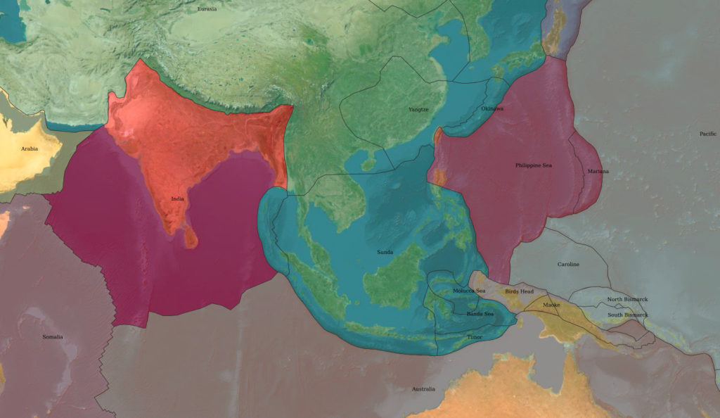
Firstly, the convergence of 2 oceanic crusts lead to have one of the crusts that dive under the other in a movement of subduction. The lower plate sinks into an ocean trench. Meanwhile a volcanic arc form on the edge of the upper plate. For example, the Marianas Trench and the Kuril Islands illustrate this event. In this type of boundary, there is a shortening of the lower plate and the upper plate remains stable.
Subduction obstruction
Then, if a continental crust extended the oceanic crust of the lower plate, the entry of this continental crust into the oceanic trench will temporarily lead to a situation of obstruction. In other words, the upper oceanic crust goes over the lower continental crust. But this situation is temporary. Indeed, the continental crust is less dense, and it cannot sink under the denser oceanic crust. It will block the movement of convergence. If the convergence continues, it is the continental crust (with a possible overlap of rocks from oceanic origin) that will take it over. Because the oceanic crust is denser, it will plunge on her turn into a reverse subduction movement. This will lead to an active continental margin.
Collision between continental and oceanic crusts
An active continental margin is a zone of convergence, which bring in contact an upper continental crust and an oceanic crust. As a result, the oceanic crust having a higher density is plunging beneath the continental crust. In conclusion, this lead to a topographic low on the ocean floor. The point on the sea floor where the colliding plates are in contact is the geographic location of the plate boundaries. The subduction of one plate under another has many consequences, such as Andesitic volcanism (or explosive or gray volcano), many earthquakes and especially the formation of folds and faults.
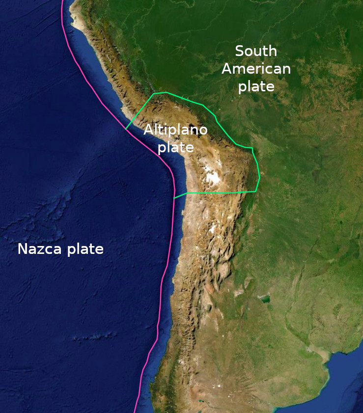
For instance, the Peru-Chile Trench (or Atacama Trench) is an example of this Ocean Trenches. The location of this trench is in the Pacific Ocean around 160 kilometers (100 miles) off the coast of Peru and Chile. It reaches a maximum depth of 8,065 m (26,460 ft) below the sea level and it is approximately 5,900 km (3,700 mi) long. The mean width is 64 km (40 mi) and it covers around 590,000 km2 (230,000 sq mi). This trench delimits the Nazca Plate that goes beneath the South American Plate.
The deepest trench in the world is the Mariana Trench (or Marianas Trench). It has a depth of 10,984 m (36,037 ft) with an imprecision of ± 25 m (82 ft).
Collision between two continental crusts
Finally, If the convergence along an active continental margin has consumed all the oceanic crust, it leads to a collision zone, where two continental crusts collide. The system of subduction is not powerful enough to let one of the plates plunge in the Asthenosphere (due to their low density). The 2 plates merged to form only one. A good example of it is the Himalaya, on the border between the Indian plate and the Eurasian plate. This meeting occurred 65 million years ago, thanks to the migration of the Indian continent. The Alps and the Atlas chains are other examples of collision chains. Because of these collisions, the sedimentary material is uplift to form mountain ranges with folded and faulted rocks.
These collisions lead to the formation of increasingly large continental masses. John Tuzo Wilson has shown that continents grow by a cycle call the Wilson cycle. It is a series of almost periodic stages in which the tectonic plates of the earth’s crust disperse and then aggregate. We will see these cycles in more details further in this article.
Transform tectonic plates boundaries
These boundaries are where two lithospheric plates slide along a transform fault. So, these boundaries are where there is no creation or destruction of plates.
During the displacement of this fault with 2 continental crusts, very violent earthquakes occur, due to rough friction along thick, slightly rectilinear faults. The San Andreas fault in California and the North Anatolian fault in Turkey are two examples of it.
Oceanic ridge is always formed by diverging segments, separated by transforming faults. However, the transforming oceanic faults in oceanic ridge environment produce nearly no earthquakes. It is because they are very rectilinear and on thin oceanic crust.
Transform boundary can also be associated with the boundary between oceanic plates and continental plates. An example of this type of boundary is the Caribbean plate and the Scotia plate boundary.
Poorly defined tectonic plates boundaries
Topographic expression or lithospheric discontinuities sometimes don’t clearly define plate boundaries. For example, the boundary of the southern edge of the Caribbean plate passing through the northern South America plate is not clearly defined.
Wilson cycle
The Wilson cycle is the model where a continental rift breaks up a continent. Firstly, as spreading continues an ocean opens between the two lithospheric plates. After the separation of the two plates, the two continental crusts converge and collide. Further, orogeny thickens the crust and build mountains. Then, the continent erodes, which lead to the thinning of the crust. Then the cycle of Wilson begins again with the continental rift that break up this continent.
These cycles have a theoretical duration of the order of 400 to 600 Ma and they started about 3 billion years ago. Since then, 8 to 12 cycles occurred over the geological time (depending on the model).
As a result, these cycles of collision / separation have led to the creation of some supercontinents.
List of supercontinents
This perpetual alteration of the earth’s surface causes the loss of the geological elements that are witnesses to past periods. For the moment, geologists have well-documented the episode of the Pangea. In addition, they only have a few elements on the previous episodes of supercontinents such as the Rodinia (between 1.1 Billion years and 750 Million years). Nevertheless, the geological archives have demonstrated the existence of various other supercontinent moments.
Thus currently, we recognize the following supercontinents:
- Pangea: around 300 Million years ago
- Pannotia: around 600 Million years ago
- Rodinia : between 1.1 Billion years and 750 Million years ago
- Columbia: from 1.8 to 1.5 billion years ago
- Kenorland: from 2.7 to 2.1 years ago
- Ur: around 3 Billion years ago
- Vaalbara: around 3.6 to 2.8 billion years ago
The next supercontinent
The ongoing closure of the Pacific ocean should lead to the formation of a new supercontinent, named Amasia by Paul F. Hoffman in 1992. This new supercontinent will form in about 100 million years and it will be centered on the north pole. Following the models, the Antarctic will not be integrated into this supercontinent.