Home / Continents / Europe / Geography

Geography of Europe

Where is Europe located on the world map?

Location of Europe on the world map

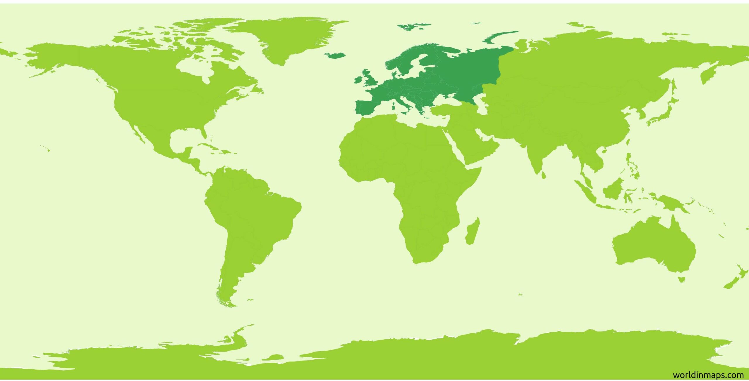
Europe is located in the westernmost part of the Eurasian plate and it is traditionally considered as one of the seven continents.

Map with the boundaries of Europe

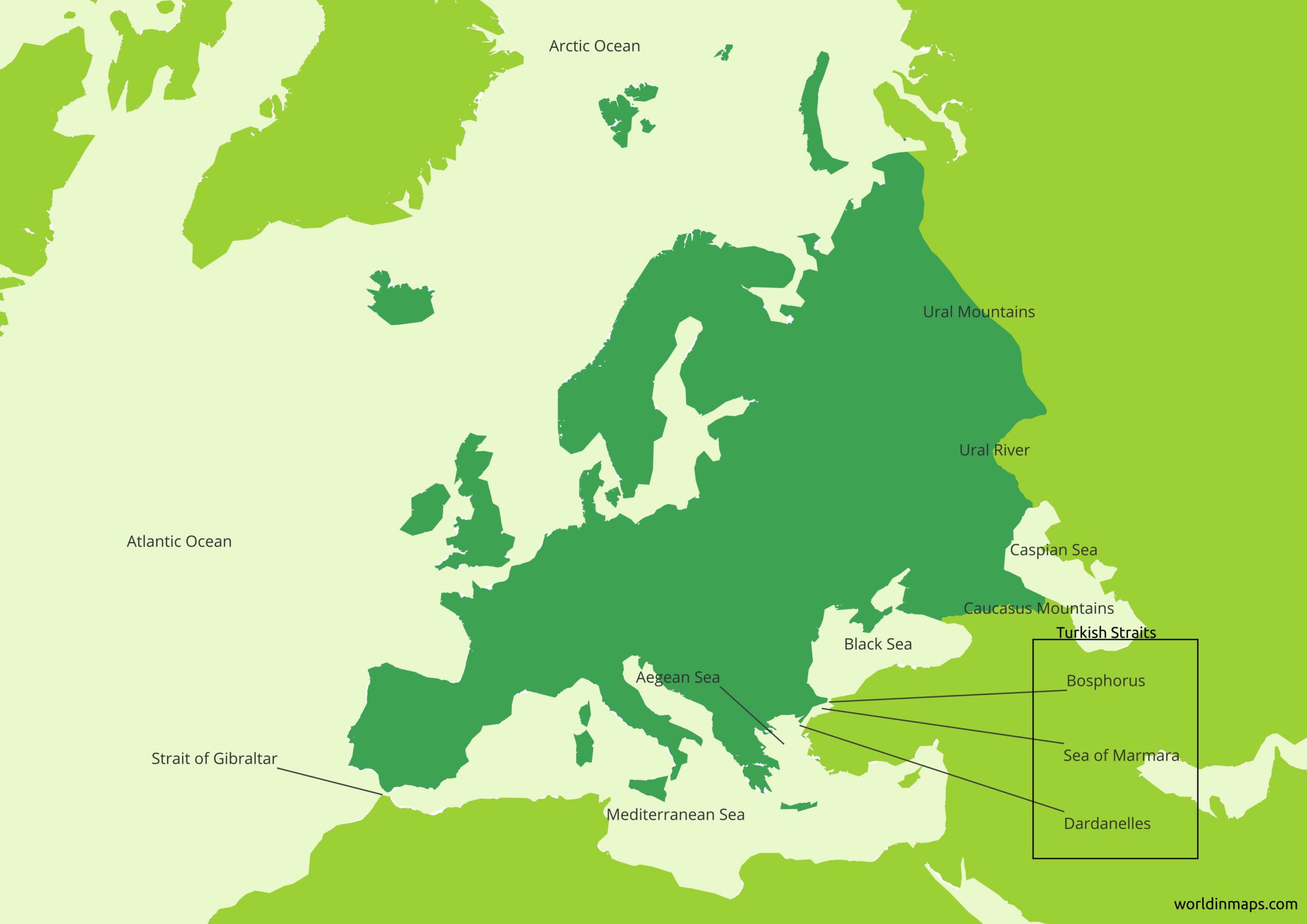
It is bordered by the Arctic Ocean to the north, the Atlantic Ocean to the west, the Gibraltar Strait, the Mediterranean Sea, the Aegean Sea, the Dardanelles Strait, the Sea of Marmara and the Bosphorus Strait to the south. The eastern boundaries with Asia are less defined, because of the lack of real natural boundaries. The current definition of the boundaries is the one wished by Peter the Great that was willing to reoriented Russia into Europe by building Saint-Petersbourg on the Baltic Sea and by moving the boundaries of Europe to the east.

This border between Europe and Asia is considered to be the watershed of the Ural Mountains, the Ural River, the Caspian Sea, the Greater Caucasus, the Black Sea and the Turkish Straits.

Political map of Europe

Political map of Europe

A common question is to know if Turkey and Russia are part of Europe or Asia. Following the definition given above, they are both on the two continents. The part of Russia located on the west of the Ural Mountains is in Europe and the part on the east is in Asia. Russia is mostly considered to be a European country because the majority of its population and its capital city are located in the European part.

For Turkey, the Turkish straits delimits the boundary between Asia and Europe. So Turkey is for its biggest part on the Asian continent, but its capital city Istanbul is located on the both continents because the border between Europe and Asia is located on the Bosphorus Strait, which cut the city in two.

Iceland is also a special case because it is located on the border between Europe and North America, but the country is considered as part of Europe.

Cyprus is also a special case and it is considered as a European country because of its long common history with Greece. In this case it is a political definition that has been taken rather than a physical one.

The attempt of Europe to integrate Turkey in the Europe show a clear willing of leaving the clear geographical definition to an area without physical limits, but based on political decisions. Above this, some island in the Atlantic, the Greenland and some overseas department are considered as part of Europe because they are part or are dependencies of a European countries and so their culture or their people are considered as European.

As a conclusion, this brings Europe to a total of 50 sovereign states.

Physical map of Europe

Physical map of Europe

Geographical features

Area 10 180 000 km²
(3 930 000 sq mi)
Lowest point
Caspian Sea (Russia / Kazakhstan)28 m (92 ft) below sea level
Highest point
Mount Elbrus (Russia)5 642 m (18 510 ft)

Major mountain ranges

Mountain rangeLocationLengthHighest point
The Ural MountainsThe Ural separates Europe from Asia in the east from the arctic ocean to the Ural River2 500 km (1 600 mi)Mount Narodnaya (1 894 m / 6 214 ft)
The Caucasus MountainsThe Caucasus Mountains also separate Europe from Asia, but in the southeast between the Black Sea and the Caspian Sea1 200 km
(750 mi)
Mount Elbrus (5642 m / 18 510 ft)
Highest peak in Europe
The Carpathian MountainsThe Carpathian Mountains range that form an arc across Central and Eastern Europe (from Czech Republic and Austria, through Slovakia, Poland, Hungary, Ukraine, Romania and Serbia)1 700 km
(1 100 mi)
Gerlachov Peak (2 654 m / 8 709 ft)
The AlpsThe Alps stretch from the Mediterranean Sea in France and Monaco, through mid and southern Switzerland, Liechtenstein, south of Germany and to Austria until Vienna and to the Adriatic Sea and Slovenia. The Alps makes an arc all around the north of Italy from the Mediterranean Sea on the west to the Adriatic Sea on the east.1 200 km
(750 mi)
Mont Blanc (4 808 m / 15 776 ft)
The Apennines Mountains or the ApenninesThe Apennines stretch from the north of Italy until the south along the whole length of the country.1 200 km
(750 mi)
Corno Grande or Great Horn in English (2 912 m / 9 554)
The Pennines (also called the Pennine Chain or Pennine Hills)The Pennines are more-or-less continuous range of hills and mountains oriented north – south in the northern part of England.435 km (268 mi)Cross Fell (893 m / 2 930 ft)
The PyreneesThe Pyrenees marks the border between France and Spain.491 km
(305 mi)
Aneto (3 404 m / 11 168 ft)
The Scandinavian Mountains (or the Scandes)The Scandinavian Mountains run through all the Scandinavian Peninsula.1 700 km
(1 100 mi)
Galdhøpiggen (2 469 m / 8 100ft)

Plains and Plateaus in Europe

Plains and PlateausLocation
The North European PlainIt consists of the low plains between the Central European Highlands in the south and the North Sea and the Baltic Sea in the north. It covers a small part of northern France, the northern part of Belgium, the Netherlands, the northern part of Germany, Denmark, the major part of Poland and a small part of the Czech Republic.
The East European Plain (also called the Russian Plain)The East European Plain is a vast interior plain and it is located east of the North European Plain. It comprises several plateaus and it limited at the west by the North European Plain, at the south by the Balkan Mountains, the Black Sea, The Crimean Mountains, the Caucasus and the Caspian Sea. To the North it is limited by the Baltic Sea, the Scandinavian Mountains, the White Sea, the Barents Sea and finally the Kara Sea. To the east the plain extends until the Ural Mountains.
The Pannonian PlainThe center of the plain is located in Hungary and most of the plain consists of the Great Hungarian Plain.
Meseta CentralThis plateau occupies the central part of the Iberian Peninsula and it is centered on Madrid and it has an area of 210 000 km² (81 000 sq mi).

The North European Plain and the East European Plain are connected and they form together the major part of the Great European Plain (also called the European Plain).

Longest rivers in Europe

Map of the longest rivers in Europe
RankRiverLengthCountries
1Volga3 531 km
(2 194 mi)
Russia
2Danube2 850 km
(1 770 mi)
GermanyAustriaSlovakiaHungary
CroatiaSerbiaBulgariaRomania
Moldova and Ukraine
3Ural2 428 km
(1 509 mi)
Russia and Kazakhstan
4Dnieper2 290 km
(1 420 mi)
Russia, Belarus and Ukraine
5Don1 950 km
(1 210 mi)
Russia
6Pechora1 809 km
(1 124 mi)
Russia
7Kama (longest left tributary of the Volga and the largest one in discharge)1 805 km
(1 122 mi)
Russia
8Oka (longest right tributary of the Volga)1 500 km
(930 mi)
Russia
9Belaya (tributary of the Kama)1 430 km
(890 mi)
Russia
10Dniester1 352 km
(840 mi)
Ukraine and Moldova
11Rhine1 230 km
(760 mi)
SwitzerlandLiechtenstein
AustriaGermanyFrance 
and Netherlands
12Desna (major left tributary of the Dnieper)1 130 km
(700 mi)
Ukraine and Russia
13Elbe1091 km
(678 mi)
Czech Republic and Germany
14Donets (major right tributary of the Don)1 053 km
(654 mi)
Russia and Ukraine
15Vistula1 047 km
(651 mi)
Poland
16Tagus1 038 km
(645 mi)
Spain and Portugal
17Daugava1 020 km
(630 mi)
Russia, Belarus and Latvia
18Loire1 012 km
(629 mi)
France
19Tisza (tributary of the Danube)966 km
(600 mi)
Before 1880: 1 358 km (844 mi)
Ukraine, Romania, Hungary,
Slovakia and Serbia
20Ebro930 km
(580 mi)
Spain
List of the 20th longest rivers in Europe