Continents / Europe / Physical
Physical map of Europe
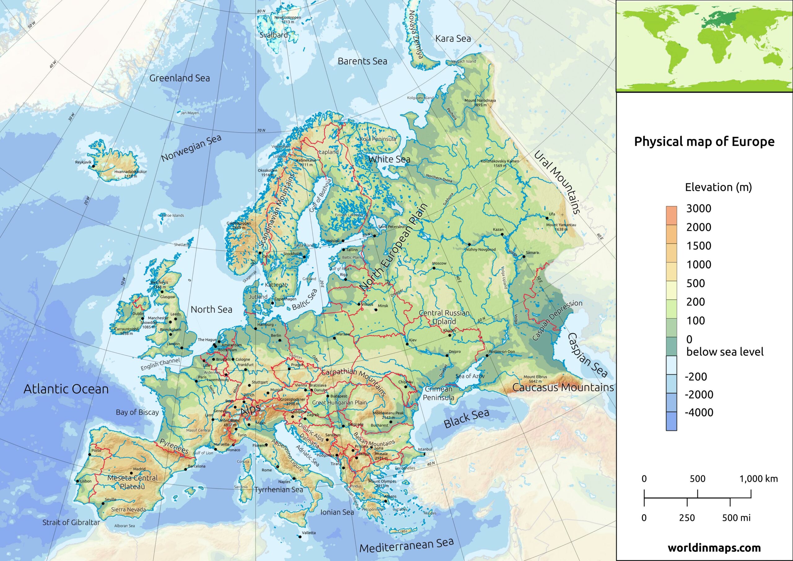
Geographical features
| Area | 10 180 000 km² (3 930 000 sq mi) |
| Lowest point | |
| Caspian Sea (Russia / Kazakhstan) | 28 m (92 ft) below sea level |
| Highest point | |
| Mount Elbrus (Russia) | 5 642 m (18 510 ft) |
Major mountain ranges
| Mountain range | Location | Length | Highest point |
|---|---|---|---|
| The Ural Mountains | The Ural separates Europe from Asia in the east from the arctic ocean to the Ural River | 2 500 km (1 600 mi) | Mount Narodnaya (1 894 m / 6 214 ft) |
| The Caucasus Mountains | The Caucasus Mountains also separate Europe from Asia, but in the southeast between the Black Sea and the Caspian Sea | 1 200 km (750 mi) | Mount Elbrus (5642 m / 18 510 ft) Highest peak in Europe |
| The Carpathian Mountains | The Carpathian Mountains range that form an arc across Central and Eastern Europe (from Czech Republic and Austria, through Slovakia, Poland, Hungary, Ukraine, Romania and Serbia) | 1 700 km (1 100 mi) | Gerlachov Peak (2 654 m / 8 709 ft) |
| The Alps | The Alps stretch from the Mediterranean Sea in France and Monaco, through mid and southern Switzerland, Liechtenstein, south of Germany and to Austria until Vienna and to the Adriatic Sea and Slovenia. The Alps makes an arc all around the north of Italy from the Mediterranean Sea on the west to the Adriatic Sea on the east. | 1 200 km (750 mi) | Mont Blanc (4 808 m / 15 776 ft) |
| The Apennines Mountains or the Apennines | The Apennines stretch from the north of Italy until the south along the whole length of the country. | 1 200 km (750 mi) | Corno Grande or Great Horn in English (2 912 m / 9 554) |
| The Pennines (also called the Pennine Chain or Pennine Hills) | The Pennines are more-or-less continuous range of hills and mountains oriented north – south in the northern part of England. | 435 km (268 mi) | Cross Fell (893 m / 2 930 ft) |
| The Pyrenees | The Pyrenees marks the border between France and Spain. | 491 km (305 mi) | Aneto (3 404 m / 11 168 ft) |
| The Scandinavian Mountains (or the Scandes) | The Scandinavian Mountains run through all the Scandinavian Peninsula. | 1 700 km (1 100 mi) | Galdhøpiggen (2 469 m / 8 100ft) |
Plains and Plateaus in Europe
| Plains and Plateaus | Location |
|---|---|
| The North European Plain | It consists of the low plains between the Central European Highlands in the south and the North Sea and the Baltic Sea in the north. It covers a small part of northern France, the northern part of Belgium, the Netherlands, the northern part of Germany, Denmark, the major part of Poland and a small part of the Czech Republic. |
| The East European Plain (also called the Russian Plain) | The East European Plain is a vast interior plain and it is located east of the North European Plain. It comprises several plateaus and it limited at the west by the North European Plain, at the south by the Balkan Mountains, the Black Sea, The Crimean Mountains, the Caucasus and the Caspian Sea. To the North it is limited by the Baltic Sea, the Scandinavian Mountains, the White Sea, the Barents Sea and finally the Kara Sea. To the east the plain extends until the Ural Mountains. |
| The Pannonian Plain | The center of the plain is located in Hungary and most of the plain consists of the Great Hungarian Plain. |
| Meseta Central | This plateau occupies the central part of the Iberian Peninsula and it is centered on Madrid and it has an area of 210 000 km² (81 000 sq mi). |
The North European Plain and the East European Plain are connected and they form together the major part of the Great European Plain (also called the European Plain).
Longest rivers in Europe

| Rank | River | Length | Countries |
|---|---|---|---|
| 1 | Volga | 3 531 km (2 194 mi) | Russia |
| 2 | Danube | 2 850 km (1 770 mi) | Germany, Austria, Slovakia, Hungary, Croatia, Serbia, Bulgaria, Romania, Moldova and Ukraine |
| 3 | Ural | 2 428 km (1 509 mi) | Russia and Kazakhstan |
| 4 | Dnieper | 2 290 km (1 420 mi) | Russia, Belarus and Ukraine |
| 5 | Don | 1 950 km (1 210 mi) | Russia |
| 6 | Pechora | 1 809 km (1 124 mi) | Russia |
| 7 | Kama (longest left tributary of the Volga and the largest one in discharge) | 1 805 km (1 122 mi) | Russia |
| 8 | Oka (longest right tributary of the Volga) | 1 500 km (930 mi) | Russia |
| 9 | Belaya (tributary of the Kama) | 1 430 km (890 mi) | Russia |
| 10 | Dniester | 1 352 km (840 mi) | Ukraine and Moldova |
| 11 | Rhine | 1 230 km (760 mi) | Switzerland, Liechtenstein, Austria, Germany, France and Netherlands |
| 12 | Desna (major left tributary of the Dnieper) | 1 130 km (700 mi) | Ukraine and Russia |
| 13 | Elbe | 1091 km (678 mi) | Czech Republic and Germany |
| 14 | Donets (major right tributary of the Don) | 1 053 km (654 mi) | Russia and Ukraine |
| 15 | Vistula | 1 047 km (651 mi) | Poland |
| 16 | Tagus | 1 038 km (645 mi) | Spain and Portugal |
| 17 | Daugava | 1 020 km (630 mi) | Russia, Belarus and Latvia |
| 18 | Loire | 1 012 km (629 mi) | France |
| 19 | Tisza (tributary of the Danube) | 966 km (600 mi) Before 1880: 1 358 km (844 mi) | Ukraine, Romania, Hungary, Slovakia and Serbia |
| 20 | Ebro | 930 km (580 mi) | Spain |