India
| Government | |
| Name | Republic of India |
| Hindi | Bhārat Gaṇarājya |
| Government type | Federal parliamentary republic |
| Capital | New Delhi – urban district located in the city of Delhi (257,803 (2011) for new Delhi and 11,007,835 (2011) for Delhi) |
| Currency | Indian rupee (INR) |
| Organization | |
| Member State | South Asian Association for Regional Cooperation (SAARC) Commonwealth of Nations |
| People | |
| Population (2020) | 1,380,004,385 (2nd) |
| Density of population | 406.5 P/km2 (19th) |
| Nationality | Indian |
| Official languages | |
| Hindi | |
| English | |
| 22 officially recognized regional languages: Assamese, Bengali, Bodo, Dogri, Gujarati, Hindi, Kannada, Kashmiri, Konkani, Maithili, Malayalam, Manipuri, Nepali, Odia, Punjabi, Sanskrit, Santali, Sindhi, Tamil, Telugu, Urdu and Hindustani | |
| Ethnic groups (2000) | |
| Indo-Aryan | 72% |
| Dravidian | 25% |
| Mongoloid and other | 3% |
| Religions (2011) | |
| Hindu | 79.8% |
| Muslim | 14.2% |
| Christian | 2.3% |
| Sikh | 1.7% |
| Other and unspecified | 2% |
| Life expectancy (2020) | |
| Male | 68.4 years |
| Female | 71.2 years |
| Total population | 69.7 years (167th) |
| Homicides | |
| Total (2018) | 3.1 per 100,000 people (82nd) |
| Geography | |
| Land area | 2,973,193 km2 |
| water area | 314,070 km2 |
| total area | 3,287,263 km2 (8th) |
| Mean elevation | 160 m |
| Lowest point | |
| Indian Ocean | 0 m |
| Highest point | |
| Kanchenjunga | 8,586 m |
| Land use (2011) | |
| Agricultural land | 60.5% |
| Arable land | 52.8% |
| Permanent crops | 4.2% |
| Permanent pasture | 3.5% |
| Forest | 23.1% |
| Other | 16.4% |
| Urbanization | |
| Urban population (2020) | 34.9% |
| Rate of urbanization | 2.37% annual rate of change (2015 – 2020) |
| Economy | |
| Labor force (2017) | 521.9 million (2nd) |
| Labor force by occupation (2014) | |
| Agriculture | 47% |
| Industry | 22% |
| Services | 31% |
| Unemployment rate (2017) | 8.5% (122nd) |
| GDP (PPP) (estimate 2020) | |
| Total | $12.363 trillion (3rd) |
| Per capita | $9,027 (118th) |
| GDP (nominal) (estimate 2020) | |
| Total | $3.202 trillion (5th) |
| Per capita | $2,338 (139th) |
| GDP by sector (estimate 2016) | |
| Agriculture | 15.4% |
| Industry | 23% |
| Services | 61.5% |
| Exports (2017) | $304.1 billion (19th) |
| Exports partners (2017) | |
| US | 15.6% |
| UAE | 10.2% |
| Hong Kong | 4.9% |
| China | 4.3% |
| Imports (2017) | $452.2 billion (11th) |
| Imports partners (2017) | |
| China | 16.3% |
| US | 5.5% |
| UAE | 5.2% |
| Saudi Arabia | 4.8% |
| Switzerland | 4.7% |
Where is India located on the world map?
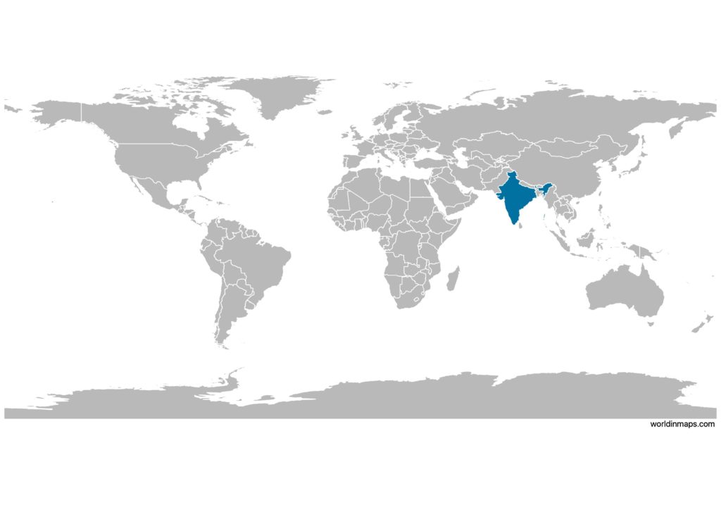
India is a huge peninsula located in southern Asia. It has about 7,500 km of coastline on the Indian Ocean. India is the second most populous country and the seventh largest country in the world.
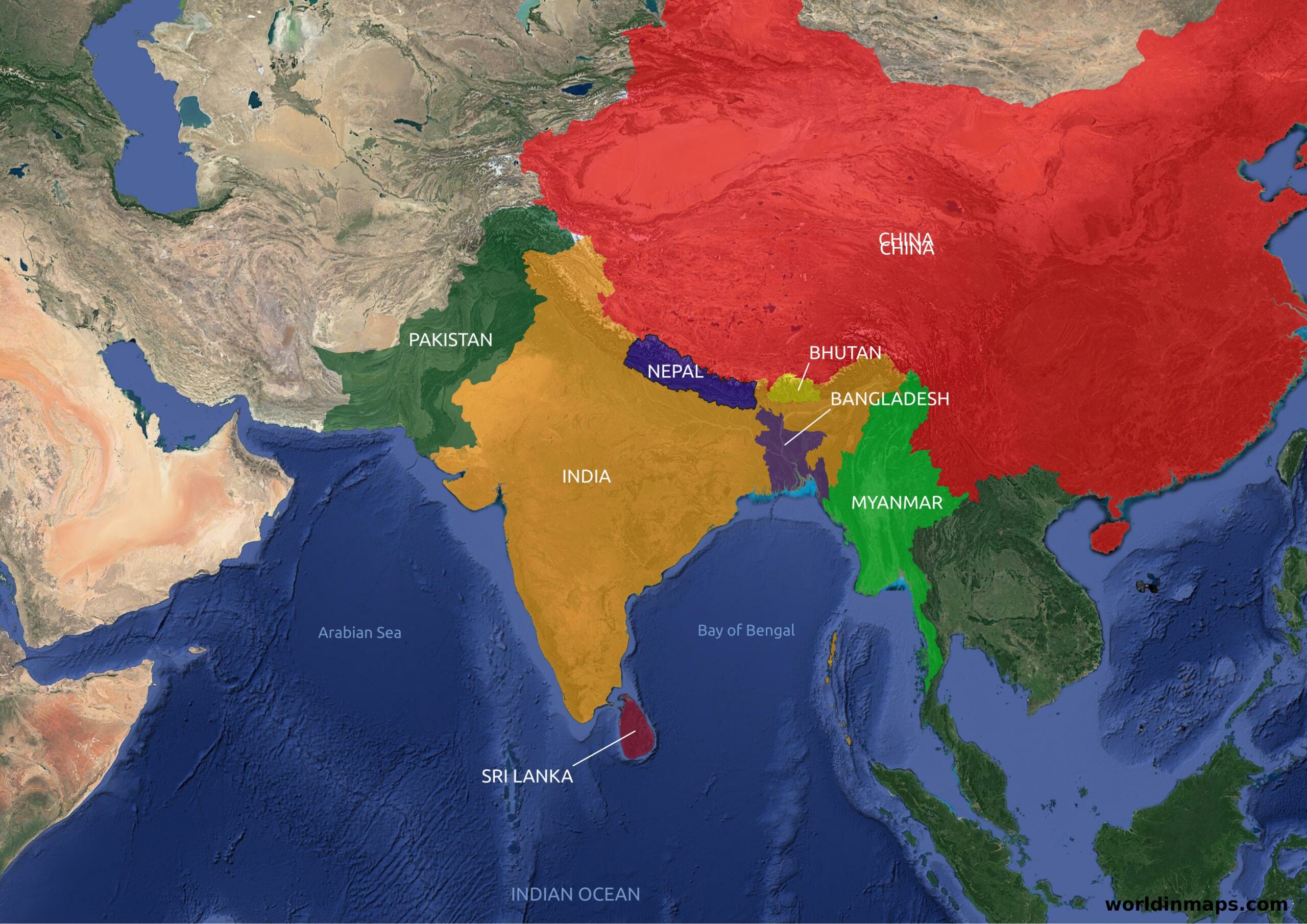
The peninsula is surrounded on the west by the Arabian Sea and on the east by the Bay of Bengal. In the latter are the Adaman-and-Nicobar Islands which belong to India.
The Indian coastline stretches for more than seven thousand kilometers. The country has common borders with Pakistan to the northwest, China to the north and east-northeast, Nepal to the northeast, Bhutan, Bangladesh and Myanmar (or Burma) to the east and northeast. On the Indian Ocean, India is close to the Maldives to the south-southwest, Sri Lanka to the south and Indonesia to the southeast.
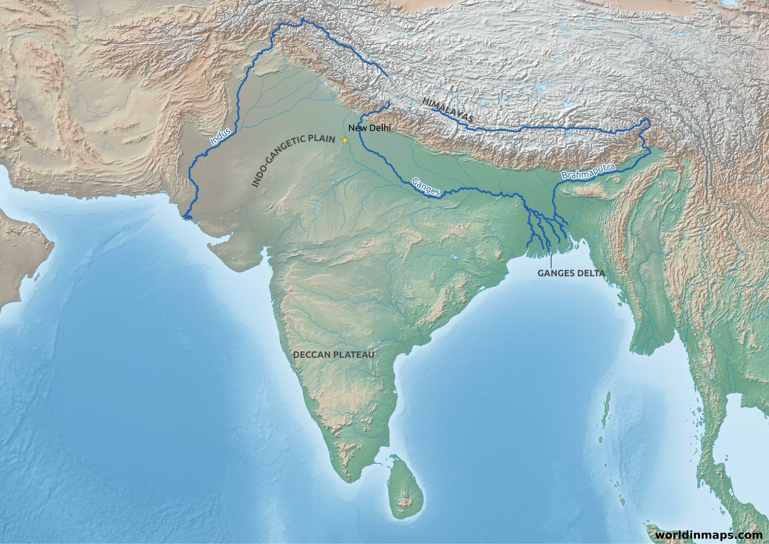
In the north, India is limited by the Himalayas from which flows the 3 major rivers of India: the Indus, the Ganges and the Brahmaputra. These 3 large rivers form a vast plain: the Indo-Gangetic plain. It is in this plain that the capital New Delhi is located. This plain forms the real historical heart of the country by sheltering high places of Indian civilization. East of the Indo-Gangetic plain, we find the largest delta in the world at the mouths of the Ganges and the Brahmaputra. As for the southern part of India, it is partly made up of the vast Deccan plateau.
Political map of India with states and cities
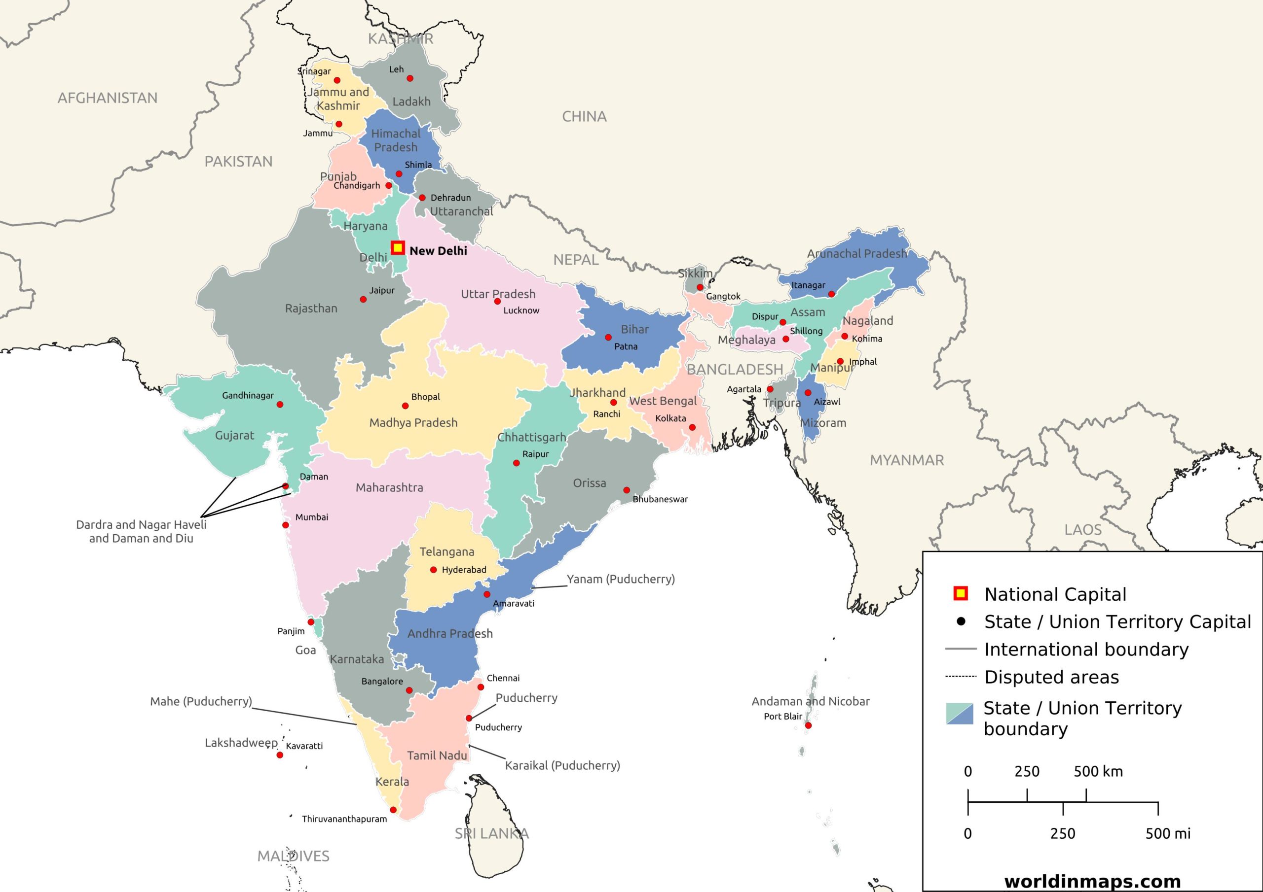
States and Union territories
States
| State | Capital | Largest city | Population | Area |
|---|---|---|---|---|
| Andhra Pradesh | Visakhapatnam (Administrative) Amaravati (Legislative) Kurnook (Judicial) | Visakhapatnam | 49,506,799 | 160,205 2 km2 |
| Arunachal Pradesh | Itanagar | Itanagar | 1,383,727 | 83,743 km2 |
| Assam | Dispur | Guwahati | 31,205,576 | 78,550 km2 |
| Bihar | Patna | Patna | 104,099,452 | 94,163 km2 |
| Chhattisgarh | Nava Raipur | Raipur | 25,545,198 | 135,194 km2 |
| Goa | Panaji | Vasco da Gama | 1,458,545 | 3,702 km2 |
| Gujarat | Gandhinagar | Ahmedabad | 60,439,692 | 196,024 km2 |
| Haryana | Chandigarh | Faridabad | 25,351,462 | 44,212 km2 |
| Himachal Pradesh | Shimla (Summer) Dharamshala (Winter) | Shimla | 6,864,602 | 55,673 km2 |
| Jharkhand | Ranchi | Jamshedpur | 32,988,134 | 74,677 km2 |
| Karnataka | Bengaluru | Bengaluru | 61,095,297 | 191,791 km2 |
| Kerala | Thiruvananthapuram | Kochi | 33,406,061 | 38,863 km2 |
| Madhya Pradesh | Bhopal | Indore | 72,626,809 | 308,252 km2 |
| Maharashtra | Mumbai (Summer) Nagpur (Winter) | Mumbai | 112,374,333 | 307,713 km2 |
| Manipur | Imphal | Imphal | 2,855,794 | 22,347 km2 |
| Meghalaya | Shillong | Shillong | 2,966,889 | 22,720 km2 |
| Mizoram | Aizawl | Aizawl | 1,097,206 | 21,081 km2 |
| Nagaland | Kohima | Dimapur | 1,978,502 | 16,579 km2 |
| Odisha | Bhubaneswar | Bhubaneswar | 41,974,218 | 155,820 km2 |
| Punjab | Chandigarh | Ludhiana | 27,743,338 | 50,362 km2 |
| Rajasthan | Jaipur | Jaipur | 68,548,437 | 342,269 km2 |
| Sikkim | Gangtok | Gangtok | 610,577 | 7,096 km2 |
| Tamil Nadu | Chennai | Chennai | 72,147,030 | 130,058 km2 |
| Telangana | Hyderabad | Hyderabad | 35,193,978 | 114,840 km2 |
| Tripura | Agartala | Agartala | 3,673,917 | 10,492 km2 |
| Uttar Pradesh | Lucknow | Kanpur | 199,812,341 | 243,286 km2 |
| Uttarakhand | Gairsain (Summer) Dehradun (Winter) | Dehradun | 10,086,292 | 53,483 km2 |
| West Bengal | Kolkata | Kolkata | 91,276,115 | 88,752 km2 |
Union territories
| State | Capital | Largest city | Population | Area |
|---|---|---|---|---|
| Andaman and Nicobar Islands | Port Blair | Port Blair | 380,581 | 8,249 km2 |
| Chandigarh | Chandigarh | – | 1,055,450 | 114 km2 |
| Dadra and Nagar Haveli and Daman and Diu | Daman | Daman | 586,956 | 603 km2 |
| Delhi | New Delhi | – | 16,787,941 | 1,490 km2 |
| Jammu and Kashmir | Srinagar (Summer) Jammu (Winter) | Srinagar | 12,258,433 | 55,538 km2 |
| Ladakh | Leh (Summer) Kargil (Winter) | Leh | 290,492 | 174,852 km2 |
| Lakshadweep | Kavaratti | Kavaratti | 64,473 | 32 km2 |
| Puducherry | Puducherry | Puducherry | 1,247,953 | 492 km2 |
River map of India
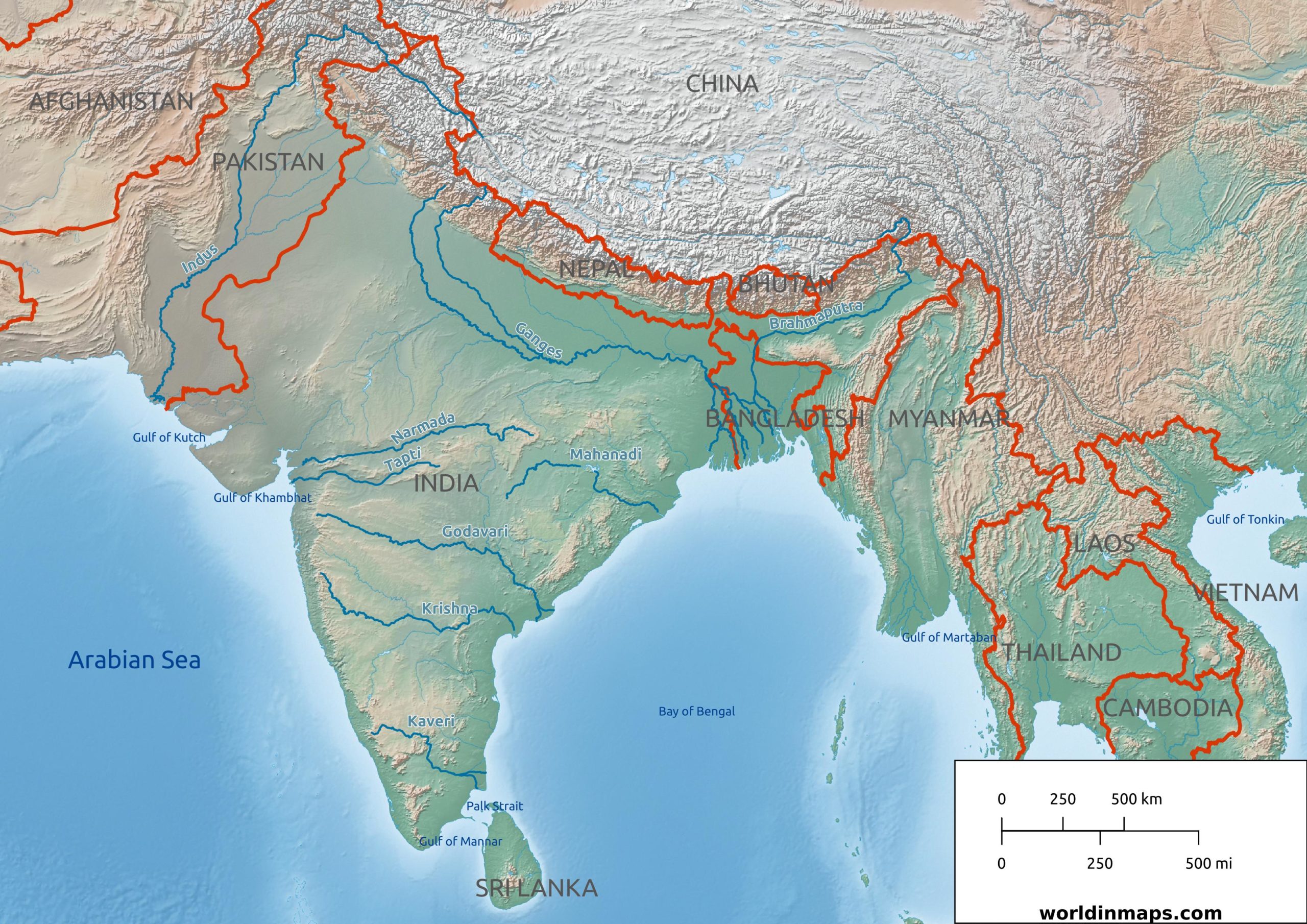
List of the major rivers of India with their length:
| Rank | Name | Length in India | Total length |
|---|---|---|---|
| 1 | Ganges | 2525 km (1569 mi) | 2525 km (1569 mi) |
| 2 | Godavari | 1465 km (910 mi) | 1465 km (910 mi) |
| 3 | Yamuna | 1376 km (855 mi) | 1376 km (855 mi) |
| 4 | Narmada | 1312 km (815 mi) | 1312 km (815 mi) |
| 5 | Krishna | 1300 km (808 mi) | 1300 km (808 mi) |
| 6 | Indus | 1114 km (692 mi) | 3180 km (1976 mi) |
| 7 | Brahmaputra | 916 km (569 mi) | 2900 km (1802 mi) |
| 8 | Mahanadi | 890 km (553 mi) | 890 km (553 mi) |
| 9 | Kaveri | 800 km (497 mi) | 800 km (497 mi) |
| 10 | Tapti | 724 km (450 mi) | 724 km (450 mi) |
India top 10 largest cities (2011)
- Mumbai (12,442,373)
- Delhi (11,007,835)
- Bangalore (8,436,675)
- Hyderabad (6,809,970)
- Ahmedabad (5,570,585)
- Chennai (4,681,087)
- Kolkata (Calcutta) (4,486,679)
- Surat (4,467,797)
- Pune (3,124,458)
- Jaipur (3,046,163)
Demography
Population pyramid
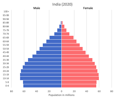
Age structure data
Estimate for 2020:
- 0-14 years: 26.31% (male 185,017,089/female 163,844,572)
- 15-24 years: 17.51% (male 123,423,531/female 108,739,780)
- 25-54 years: 41.56% (male 285,275,667/female 265,842,319)
- 55-64 years: 7.91% (male 52,444,817/female 52,447,038)
- 65 years and over: 6.72% (male 42,054,459/female 47,003,975)
Remark: the age structure of a population affects a nation’s key socioeconomic issues. Countries with young populations (high percentage under age 15) need to invest more in schools, while countries with older populations (high percentage ages 65 and over) need to invest more in the health sector. The age structure can also be used to help predict potential political issues. For example, the rapid growth of a young adult population unable to find employment can lead to unrest.
Population from 1950 to 2020
Source: United Nations, Department of Economic and Social Affairs, Population Division (2019). World Population Prospects 2019, Online Edition. Rev. 1.
India’s population has more or less doubled in 50 years and in 2020 it was estimated to be around 1.3 billion people. Which makes it the second most populous country in the world behind China (around 1.4 billion).
Density of population

India’s population density is also among the highest in the world. The population is mainly concentrated in large urban centers and in the Indo-Gangetic Plain.
The population is predominantly rural (2/3 of the population live in the countryside), but India, however, has more than 7 cities with more than 5 million inhabitants (Mumbai, Kolkata, Bangalore, Chennai – formerly known as Madras, Hyderabad, Ahmedabad and Delhi). There are also many cities with more than 1 million inhabitants, which are spread over the whole territory.
Evolution of the life expectancy from 1960 to 2018
Source: World Development Indicators, The World Bank
Religion
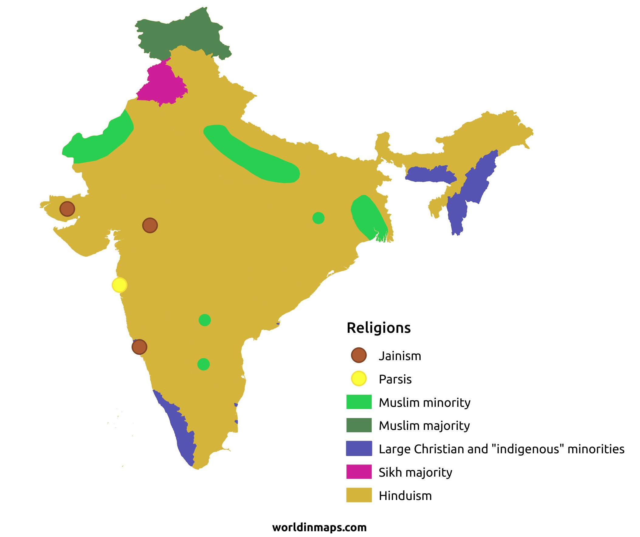
India is predominantly Hindu. Hinduism accounts for about 79.8% of pollution and coexists with large minorities. Among which Muslims who account for about 14.2% of the population. With these 172 million Muslims, India is the third largest Muslim country in the world. Then follow the Christians with 2.3% pollution. Then the Sikhs with 1.7% of the pollution. Then the Buddhists with 0.3% of the pollution and finally the Jains with 0.3% of the Indian pollution.
Economy
Agriculture:
rice, wheat, oilseed, cotton, jute, tea, sugarcane, lentils, onions, potatoes; dairy products, sheep, goats, poultry; fish
Industries:
textiles, chemicals, food processing, steel, transportation equipment, cement, mining, petroleum, machinery, software, pharmaceuticals
Exports – commodities:
petroleum products, precious stones, vehicles, machinery, iron and steel, chemicals, pharmaceutical products, cereals, apparel
Imports – commodities:
crude oil, precious stones, machinery, chemicals, fertilizer, plastics, iron and steel
Time zone and current time in India
Go to our interactive map to get the current time in India